|
search place name
|
||
Sougraigne (Languedoc-Roussillon, France)Sougraigne is a town in the Languedoc-Roussillon region of France. An overview map of the region around Sougraigne is displayed below.
regional and 3d topo map of Sougraigne, France ::

Sougraigne airports ::
The nearest airport is CCF - Carcassonne Salvaza, located 35.3 km north of Sougraigne.
Other airports nearby include PGF - Perpignan Rivesaltes (46.1 km east), DCM - Castres Mazamet (73.1 km north), BZR - Beziers Vias (94.3 km north east), LEU - Seo De Urgel (99.2 km south west), Nearby towns ::
Bugarach (1.9km south) //
Rennes-les-Bains (3.3km north west) //
Saint-Louis-et-Parahou (6.2km south west) //
Arques (6.2km north east) //
Serres (6.2km north west) //
Cassaignes (6.9km north west) //
Peyrolles (7.9km north) //
Coustaussa (7.8km north west) //
[all distances 'as the bird flies' and approximate] 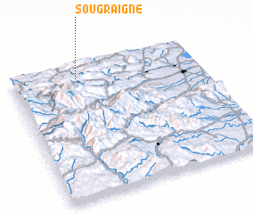 Places with similar names to Sougraigne, France ::
// Sikarákion (GR)
// Sokrákion (GR)
// Zagoričani (BA)
// Zagračani (MK)
// Sagarkan (IR)
// Sekroken (LR)
// Skaručna (SI)
// Skřečoň (CZ)
// Screggan (IE)
// Sokerkino (RU)
Disclaimer :: Information on this page comes without warranty of any kind |
||
|
Where is Sougraigne? Elevation and coordinates ::
Latitude (lat): 42°54'0"N Longitude (lon): 2°21'0"E
Elevation (approx.): 400m (map arrows pan, magnifying glasses zoom) |
||
|
Visiting Sougraigne? Hotel/Accommodation ::
Book a hotel in Sougraigne Travel Guide ::
Buy a travel guide for France rental cars ::
car rental offers GPS waypoint ::
download a GPX waypoint (PoI) of Sougraigne for your GPS receiver
|
||