|
search place name
|
||
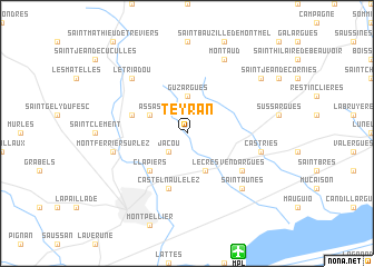
Teyran (Languedoc-Roussillon, France)Teyran is a town in the Languedoc-Roussillon region of France. An overview map of the region around Teyran is displayed below.
regional and 3d topo map of Teyran, France ::
Teyran airports ::
The nearest airport is MPL - Montpellier Mediterranee, located 12.5 km south of Teyran.
Other airports nearby include FNI - Nimes Garons (41.1 km east), BZR - Beziers Vias (60.6 km south west), AVN - Avignon Caumont (83.1 km east), MEN - Mende Brenoux (96.0 km north), Nearby towns ::
Jacou (2.3km south west) //
Guzargues (3.7km north) //
Le Crès (3.9km south) //
Saint-Vincent-de-Barbeyrargues (3.3km north west) //
Assas (3.3km north west) //
Clapiers (4.6km south west) //
Prades-le-Lez (4.4km north west) //
Castelnau-le-Lez (5.7km south) //
Vendargues (5.5km south east) //
Castries (5.7km east) //
Montferrier-sur-Lez (5.7km west) //
Le Triadou (6.9km north west) //
Saint-Aunès (6.9km south east) //
Montaud (7.9km north) //
Saint-Drézéry (7.7km north east) //
[all distances 'as the bird flies' and approximate] 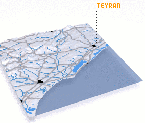 Places with similar names to Teyran, France ::
Disclaimer :: Information on this page comes without warranty of any kind |
||
|
Where is Teyran? Elevation and coordinates ::
Latitude (lat): 43°41'0"N Longitude (lon): 3°55'0"E
Elevation (approx.): 64m (map arrows pan, magnifying glasses zoom) |
||
|
Visiting Teyran? Hotel/Accommodation ::
Book a hotel in Teyran Travel Guide ::
Buy a travel guide for France rental cars ::
car rental offers GPS waypoint ::
download a GPX waypoint (PoI) of Teyran for your GPS receiver
|
||