|
search place name
|
||
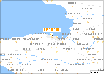
Tréboul (Bretagne, France)Tréboul is a town in the Bretagne region of France. An overview map of the region around Tréboul is displayed below.
regional and 3d topo map of Tréboul, France ::
Tréboul airports ::
The nearest airport is UIP - Quimper Pluguffan, located 19.4 km south east of Tréboul.
Other airports nearby include BES - Brest Guipavas (39.0 km north), MXN - Morlaix Ploujean (68.5 km north east), LRT - Lorient Lann Bihoue (77.8 km south east), LAI - Lannion (97.6 km north east), Nearby towns ::
Les Sables Blancs (0.0km north) //
Saint-Jean (0.0km north) //
Douarnenez (1.2km east) //
Plomarcʼh-Tosta (2.5km east) //
Quilvouarn (2.5km west) //
Brunguen (3.7km south) //
Ploaré (3.1km south east) //
Pouldavid-sur-Mer (3.9km south) //
Grand Ris (3.7km east) //
Pouldergat (5.7km south) //
Haut Kerinec (5.2km south west) //
Kerviny (6.1km south west) //
Kerandraou (5.0km west) //
Lésaouvréguen (5.0km west) //
Poullan-sur-Mer (5.3km west) //
Lesperbé (6.7km south east) //
Créach-Guennou (8.9km north east) //
[all distances 'as the bird flies' and approximate] 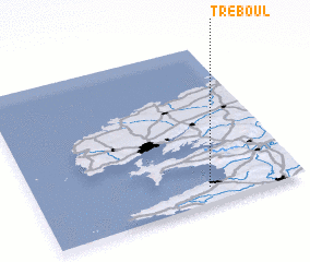 Places with similar names to Tréboul, France ::
Disclaimer :: Information on this page comes without warranty of any kind |
||
|
Where is Tréboul? Elevation and coordinates ::
Latitude (lat): 48°6'0"N Longitude (lon): 4°21'0"W
Elevation (approx.): 14m (map arrows pan, magnifying glasses zoom) |
||
|
Visiting Tréboul? Hotel/Accommodation ::
Book a hotel in Tréboul Travel Guide ::
Buy a travel guide for France rental cars ::
car rental offers GPS waypoint ::
download a GPX waypoint (PoI) of Tréboul for your GPS receiver
|
||