|
search place name
|
||
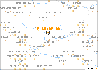
Val-des-Prés (Provence-Alpes-Côte dʼAzur, France)Val-des-Prés is a town in the Provence-Alpes-Côte dʼAzur region of France. An overview map of the region around Val-des-Prés is displayed below.
regional and 3d topo map of Val-des-Prés, France ::
Val-des-Prés airports ::
The nearest airport is TRN - Torino, located 81.0 km east of Val-des-Prés.
Other airports nearby include CUF - Levaldigi (86.9 km south east), CMF - Chambery Aix Les Bains (99.1 km north west), GNB - Grenoble Saint Geoirs (115.9 km north west), NCY - Annecy Meythet (118.1 km north west), Nearby towns ::
Le Rosier (1.9km south) //
Les Alberts (3.7km south) //
La Vachette (3.9km south) //
Granon (3.2km north west) //
Montgenèvre (3.2km south east) //
Plampinet (5.7km north) //
Briançon (6.1km south west) //
Le Fontenil (6.1km south west) //
Chalets des Acles (7.5km north) //
Claviere (5.6km east) //
Forville (6.4km south west) //
Puy-Saint-Pierre (7.6km south west) //
Pont-de-Cervières (8.4km south west) //
Le Cros (9.1km north west) //
Névache (9.1km north west) //
Saint-Blaise (9.1km south west) //
Chamandrin (9.1km south west) //
Les Fraches (9.1km south east) //
Lachau (9.1km south east) //
[all distances 'as the bird flies' and approximate]  Places with similar names to Val-des-Prés, France :: Disclaimer :: Information on this page comes without warranty of any kind |
||
|
Where is Val-des-Prés? Elevation and coordinates ::
Latitude (lat): 44°57'0"N Longitude (lon): 6°41'0"E
Elevation (approx.): 1442m (map arrows pan, magnifying glasses zoom) |
||
|
Visiting Val-des-Prés? Hotel/Accommodation ::
Book a hotel in Val-des-Prés Travel Guide ::
Buy a travel guide for France rental cars ::
car rental offers GPS waypoint ::
download a GPX waypoint (PoI) of Val-des-Prés for your GPS receiver
|
||