|
search place name
|
||
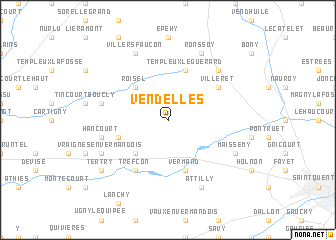
Vendelles (Picardie, France)Vendelles is a town in the Picardie region of France. An overview map of the region around Vendelles is displayed below.
regional and 3d topo map of Vendelles, France ::
Vendelles airports ::
The nearest airport is LIL - Lille Lesquin, located 71.8 km north of Vendelles.
Other airports nearby include CSF - Creil (86.1 km south west), BVA - Beauvais Tille (89.8 km south west), RHE - Reims Champagne (94.6 km south east), QKT - Kortrijk-vevelgem Wevelgem (100.3 km north), Nearby towns ::
Hesbécourt (1.9km north) //
Hervilly (2.2km north west) //
Jeancourt (2.2km north east) //
Le Verguier (3.0km north east) //
Roisel (4.4km north west) //
Poeuilly (4.4km south west) //
Vermand (5.7km south) //
Templeux-le-Guérard (5.7km north) //
Bernes (4.0km south west) //
Caulaincourt (6.1km south west) //
Trefcon (6.1km south west) //
Villeret (5.2km north east) //
Marquaix (5.1km west) //
Hancourt (5.1km west) //
Hargicourt (6.6km north east) //
Villers-Faucon (7.8km north) //
Ronssoy (7.8km north) //
Lempire (7.8km north) //
Vraignes-en-Vermandois (6.0km south west) //
Attilly (7.8km south) //
Maissemy (6.0km south east) //
Tertry (7.3km south west) //
[all distances 'as the bird flies' and approximate]  Places with similar names to Vendelles, France ::
Disclaimer :: Information on this page comes without warranty of any kind |
||
|
Where is Vendelles? Elevation and coordinates ::
Latitude (lat): 49°55'0"N Longitude (lon): 3°8'0"E
Elevation (approx.): 87m (map arrows pan, magnifying glasses zoom) |
||
|
Visiting Vendelles? Hotel/Accommodation ::
Book a hotel in Vendelles Travel Guide ::
Buy a travel guide for France rental cars ::
car rental offers GPS waypoint ::
download a GPX waypoint (PoI) of Vendelles for your GPS receiver
|
||