|
search place name
|
||
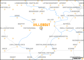
Villebout (Centre, France)Villebout is a town in the Centre region of France. An overview map of the region around Villebout is displayed below.
regional and 3d topo map of Villebout, France ::
Villebout airports ::
The nearest airport is ORE - Orleans Bricy, located 43.1 km east of Villebout.
Other airports nearby include TUF - Tours Val De Loire (70.2 km south west), LME - Le Mans Arnage (73.4 km west), TNF - Toussous-le-noble Toussus Le Noble (109.5 km north east), ORY - Paris Orly (120.0 km north east), Nearby towns ::
Ruan (4.5km north west) //
LʼAllier (4.5km north east) //
Fontaine-Raoul (3.7km west) //
Cloyes-sur-le-Loir (4.2km north east) //
Montigny-le-Gannelon (5.3km north east) //
Langey (7.4km north) //
Saint-Hilaire-la-Gravelle (7.5km south) //
Saint-Jean-Froidmentel (6.2km south east) //
Boisgasson (7.8km north) //
Saint-Hilaire-sur-Yerre (7.5km north east) //
[all distances 'as the bird flies' and approximate] 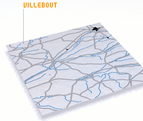 Places with similar names to Villebout, France ::
// Velebit (BA)
// Velebit (BA)
// Valea Badii (RO)
// Valea Botei (RO)
// Valea Buţii (RO)
// Phulbāti (BD)
// Villa Betty (CO)
// Fal Abdou (NE)
// Fal Bada (NE)
// Falabut (SD)
Disclaimer :: Information on this page comes without warranty of any kind |
||
|
Where is Villebout? Elevation and coordinates ::
Latitude (lat): 47°59'0"N Longitude (lon): 1°11'0"E
Elevation (approx.): 134m (map arrows pan, magnifying glasses zoom) |
||
|
Visiting Villebout? Hotel/Accommodation ::
Book a hotel in Villebout Travel Guide ::
Buy a travel guide for France rental cars ::
car rental offers GPS waypoint ::
download a GPX waypoint (PoI) of Villebout for your GPS receiver
|
||