|
search place name
|
||
Villeparisis (Île-de-France, France)Villeparisis is a town in the Île-de-France region of France. An overview map of the region around Villeparisis is displayed below.
regional and 3d topo map of Villeparisis, France ::

nearby GPS traces from timatio ::
Villeparisis airports ::
The nearest airport is CDG - Paris Charles De Gaulle, located 10.1 km north west of Villeparisis.
Other airports nearby include LBG - Paris Le Bourget (13.5 km west), ORY - Paris Orly (29.9 km south west), CSF - Creil (36.3 km north), TNF - Toussous-le-noble Toussus Le Noble (42.6 km south west), Nearby towns ::
Le Pin (1.9km south) //
Courtry (2.2km south west) //
Villevaudé (3.1km south east) //
Coubron (3.1km south west) //
Mitry-Mory (5.6km north) //
Vaujours (3.7km west) //
Brou-sur-Chantereine (5.7km south) //
Chelles (5.7km south) //
Montfermeil (5.2km south west) //
Gressy (5.2km north east) //
Clichy-sous-Bois (5.2km west) //
Livry-Gargan (5.2km west) //
Vaires-sur-Marne (7.8km south) //
Gournay-sur-Marne (8.3km south west) //
Pomponne (7.4km south east) //
Tremblay-lès-Gonesse (7.4km north west) //
Compans (8.3km north east) //
Saint-Thibault-des-Vignes (8.9km south east) //
[all distances 'as the bird flies' and approximate] 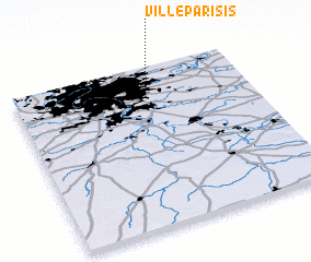 Places with similar names to Villeparisis, France :: Disclaimer :: Information on this page comes without warranty of any kind |
||
|
Where is Villeparisis? Elevation and coordinates ::
Latitude (lat): 48°56'0"N Longitude (lon): 2°37'0"E
Elevation (approx.): 77m (map arrows pan, magnifying glasses zoom) |
||
|
Visiting Villeparisis? Hotel/Accommodation ::
Book a hotel in Villeparisis Travel Guide ::
Buy a travel guide for France rental cars ::
car rental offers GPS waypoint ::
download a GPX waypoint (PoI) of Villeparisis for your GPS receiver
|
||