|
search place name
|
||
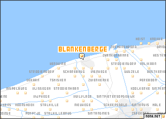
Blankenberge (West-Vlaanderen, Belgium)Blankenberge is a town in the West-Vlaanderen region of Belgium. An overview map of the region around Blankenberge is displayed below.
regional and 3d topo map of Blankenberge, Belgium ::
Blankenberge airports ::
The nearest airport is OST - Oostende, located 23.0 km south west of Blankenberge.
Other airports nearby include QKT - Kortrijk-vevelgem Wevelgem (55.8 km south), LIL - Lille Lesquin (84.0 km south), WOE - Woensdrecht (85.4 km east), CQF - Calais Dunkerque (91.4 km south west), Nearby towns ::
Uitkerke (1.9km south) //
Hoogplaat (1.9km south) //
Harendijk (2.2km south west) //
Colombus (2.2km south east) //
Sint-Jan-op-den-Dijk (3.7km south) //
Scharebrug (3.9km south) //
De Meiboom (3.9km south) //
Vierwege (4.4km south east) //
Schoeringbrug (5.6km south) //
Braambeierhoek (3.5km east) //
Wenduine (3.9km south west) //
Molenwijk (3.9km south west) //
Lissewege (3.9km south east) //
Zuienkerke (6.0km south east) //
Nieuwmunster (5.1km south west) //
Zwankendamme (4.6km east) //
Zeebrugge (5.0km east) //
Poermolen (5.0km east) //
Nieuwdorp (5.0km east) //
ʼt Smisken (6.6km south west) //
Strooienhaan (7.8km south) //
[all distances 'as the bird flies' and approximate]  Places with similar names to Blankenberge, Belgium :: Disclaimer :: Information on this page comes without warranty of any kind |
||
|
Where is Blankenberge? Elevation and coordinates ::
Latitude (lat): 51°19'0"N Longitude (lon): 3°8'0"E
Elevation (approx.): 13m (map arrows pan, magnifying glasses zoom) |
||
|
Visiting Blankenberge? Hotel/Accommodation ::
Book a hotel in Blankenberge Travel Guide ::
Buy a travel guide for Belgium rental cars ::
car rental offers GPS waypoint ::
download a GPX waypoint (PoI) of Blankenberge for your GPS receiver
|
||