|
search place name
|
||
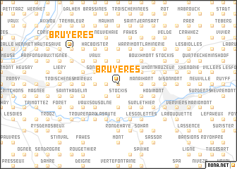
Bruyères (Liège, Belgium)Bruyères is a town in the Liège region of Belgium. An overview map of the region around Bruyères is displayed below.
regional and 3d topo map of Bruyères, Belgium ::
Bruyères airports ::
The nearest airport is LGG - Liege, located 24.2 km west of Bruyères.
Other airports nearby include MST - Maastricht (32.8 km north), GKE - Geilenkirchen (42.4 km north east), MGL - Moenchengladbach Monchengladbach (85.0 km north east), CRL - Charleroi Brussels South (95.9 km west), Nearby towns ::
Biomont (0.0km north) //
Xhawirs (1.2km west) //
Stockis (1.9km south) //
Cour à Xhendelesse (1.9km south) //
José (2.2km north west) //
Herve (2.2km north east) //
Elvaux (2.2km north east) //
Falhez (2.2km south west) //
La Bouteille (2.2km south west) //
Xhendelesse (2.2km south west) //
Belle Fontaine (3.7km north) //
Bas Bois (2.4km west) //
Bois lʼÉvêque (2.4km west) //
Soumagne (2.4km west) //
Manaihant (2.4km east) //
Le Chêne (3.7km south) //
Soiron (3.7km south) //
Saint-Germain (3.7km south) //
Noblehaie (3.9km north) //
Sarémont (3.9km north) //
Sonkeu (3.0km north west) //
Xhéneumont (3.0km north east) //
Grand-Rechain (3.0km south east) //
Basse Tribomont (3.0km south east) //
Haute Tribomont (3.9km south) //
Vaux (4.4km north west) //
Bouxhmont (4.4km north east) //
Battice (4.4km north east) //
Vaux sous Olne (4.4km south west) //
[all distances 'as the bird flies' and approximate] 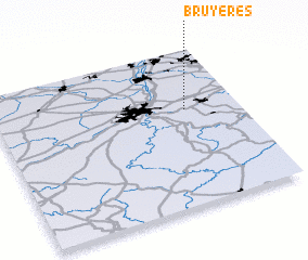 Places with similar names to Bruyères, Belgium ::
Disclaimer :: Information on this page comes without warranty of any kind |
||
|
Where is Bruyères? Elevation and coordinates ::
Latitude (lat): 50°37'0"N Longitude (lon): 5°47'0"E
Elevation (approx.): 254m (map arrows pan, magnifying glasses zoom) |
||
|
Visiting Bruyères? Hotel/Accommodation ::
Book a hotel in Bruyères Travel Guide ::
Buy a travel guide for Belgium rental cars ::
car rental offers GPS waypoint ::
download a GPX waypoint (PoI) of Bruyères for your GPS receiver
|
||