|
search place name
|
||
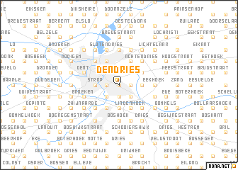
Den Dries (Oost-Vlaanderen, Belgium)Den Dries is a town in the Oost-Vlaanderen region of Belgium. An overview map of the region around Den Dries is displayed below.
regional and 3d topo map of Den Dries, Belgium ::
Den Dries airports ::
The nearest airport is QKT - Kortrijk-vevelgem Wevelgem, located 46.3 km south west of Den Dries.
Other airports nearby include ANR - Antwerp Deurne (51.6 km east), BRU - Brussels Natl (Melsbroek) (52.5 km east), WOE - Woensdrecht (61.3 km north east), OST - Oostende (66.0 km west), Nearby towns ::
Brusselse Voorstad (0.0km north) //
Schelde (1.2km east) //
Helsdries (1.9km south) //
Ledeberg (1.2km west) //
Rotsenheirweg (2.2km south east) //
Zwaanhoek (2.2km south east) //
Vogelhoek (2.2km south east) //
Eenbeek Einde (2.2km north east) //
Krabbenberg (2.2km north east) //
Terhand (2.2km south west) //
Gentbrugge (2.2km north west) //
Begijnhof ʼs Wijk (2.2km north west) //
Heusden (2.3km east) //
Klaverken (2.3km east) //
Mijleke (3.7km south) //
Strop (2.3km west) //
Zwijnaardsedries (2.3km west) //
Lindenhoek (3.9km south) //
Destelbergen (3.0km north east) //
Merelbeke (3.9km south) //
Abeelbroekstraat (3.9km north) //
Sint-Amandsberg (3.9km north) //
Melle (4.4km south east) //
Appelhoek (4.4km south east) //
Hoeksken (4.4km south east) //
Achtendries (4.4km north east) //
Klein Gent (4.4km north east) //
Nederzwijnaarde (4.4km south west) //
Sas van Gent Wijk (4.4km north west) //
[all distances 'as the bird flies' and approximate]  Places with similar names to Den Dries, Belgium ::
// Ðondraši (BA)
// Din Tarsa (RO)
// Tintores (ES)
// Denny Terrace (US)
// Dindérésso (BF)
// Tenedores (GT)
// Tandurusa (ID)
// Tanatarci (MK)
// Tendruasi (GH)
// Tendurasi (GH)
Disclaimer :: Information on this page comes without warranty of any kind |
||
|
Where is Den Dries? Elevation and coordinates ::
Latitude (lat): 51°2'0"N Longitude (lon): 3°46'0"E
Elevation (approx.): 7m (map arrows pan, magnifying glasses zoom) |
||
|
Visiting Den Dries? Hotel/Accommodation ::
Book a hotel in Den Dries Travel Guide ::
Buy a travel guide for Belgium rental cars ::
car rental offers GPS waypoint ::
download a GPX waypoint (PoI) of Den Dries for your GPS receiver
|
||