|
search place name
|
||
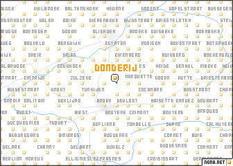
Donderij (Oost-Vlaanderen, Belgium)Donderij is a town in the Oost-Vlaanderen region of Belgium. An overview map of the region around Donderij is displayed below.
regional and 3d topo map of Donderij, Belgium ::
Donderij airports ::
The nearest airport is QKT - Kortrijk-vevelgem Wevelgem, located 29.3 km west of Donderij.
Other airports nearby include LIL - Lille Lesquin (44.7 km south west), BRU - Brussels Natl (Melsbroek) (62.5 km east), CRL - Charleroi Brussels South (69.4 km south east), OST - Oostende (70.3 km north west), Nearby towns ::
Poesthem (1.2km east) //
Boskant (1.2km east) //
Kleije (1.2km east) //
Kathoek (1.9km south) //
Boekendries (1.9km south) //
Hogenberg (1.9km south) //
Maalzak (1.9km north) //
Nederolbeek (1.9km north) //
Holand (1.2km west) //
Ruitegem (1.2km west) //
Louise Marie (2.2km south east) //
Drappendries (2.2km north east) //
Bossenare (2.2km north east) //
Steenbeekdries (2.2km north west) //
Haute (2.3km east) //
Marquette (2.3km east) //
Grote Marijve (3.7km south) //
Etikhove (3.7km north) //
Dries (3.7km north) //
Lorette (3.0km south east) //
Matersveld (3.9km south) //
Den Hul (3.9km south) //
Klein Frankrijk (3.9km south) //
De Vloet (3.9km south) //
Rattepoelmeers (3.0km north east) //
Hokelbeke (3.0km north east) //
Kerkem (3.0km north east) //
Hasselhoek (3.0km north east) //
Maarke-Kerkem (3.0km north east) //
[all distances 'as the bird flies' and approximate] 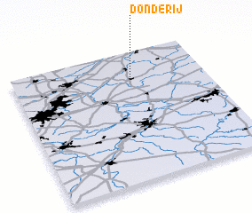 Places with similar names to Donderij, Belgium ::
Disclaimer :: Information on this page comes without warranty of any kind |
||
|
Where is Donderij? Elevation and coordinates ::
Latitude (lat): 50°47'0"N Longitude (lon): 3°37'0"E
Elevation (approx.): 56m (map arrows pan, magnifying glasses zoom) |
||
|
Visiting Donderij? Hotel/Accommodation ::
Book a hotel in Donderij Travel Guide ::
Buy a travel guide for Belgium rental cars ::
car rental offers GPS waypoint ::
download a GPX waypoint (PoI) of Donderij for your GPS receiver
|
||