|
search place name
|
||
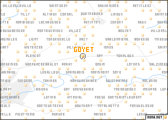
Goyet (Namur, Belgium)Goyet is a town in the Namur region of Belgium. An overview map of the region around Goyet is displayed below.
regional and 3d topo map of Goyet, Belgium ::
Goyet airports ::
The nearest airport is CRL - Charleroi Brussels South, located 15.3 km west of Goyet.
Other airports nearby include BRU - Brussels Natl (Melsbroek) (48.3 km north), LGG - Liege (57.6 km east), ANR - Antwerp Deurne (79.9 km north), MST - Maastricht (91.4 km north east), Nearby towns ::
Sur les Ternes (0.0km north) //
Onoz (0.0km north) //
Froidmont (1.9km south) //
Jemeppe (1.9km south) //
Fayat (1.2km west) //
Moustier (2.2km south east) //
Villeret (2.2km north west) //
Trieux de Goyet (2.4km east) //
Spy (2.4km east) //
Mazy (3.7km north) //
Alvaux (3.7km north) //
Fontenelle (3.9km south) //
La Sauvenière (3.0km south east) //
Ordin (3.0km south east) //
Grand Bois (3.9km south) //
La Sarte (3.0km south west) //
Alnoir (3.0km south west) //
Prahy (3.0km south west) //
Bossière (3.9km north) //
Saint-Martin (3.0km north west) //
Balâtre (3.0km north west) //
Bothey (3.9km north) //
Mornimont (4.4km south east) //
Le Rabot (4.4km south east) //
Golzinne (4.4km north east) //
Ham-sur-Sambre (5.6km south) //
Vichenet (5.6km north) //
Velaine (4.0km south west) //
Haute Bise (5.7km north) //
[all distances 'as the bird flies' and approximate]  Places with similar names to Goyet, Belgium ::
Disclaimer :: Information on this page comes without warranty of any kind |
||
|
Where is Goyet? Elevation and coordinates ::
Latitude (lat): 50°29'0"N Longitude (lon): 4°40'0"E
Elevation (approx.): 106m (map arrows pan, magnifying glasses zoom) |
||
|
Visiting Goyet? Hotel/Accommodation ::
Book a hotel in Goyet Travel Guide ::
Buy a travel guide for Belgium rental cars ::
car rental offers GPS waypoint ::
download a GPX waypoint (PoI) of Goyet for your GPS receiver
|
||