|
search place name
|
||
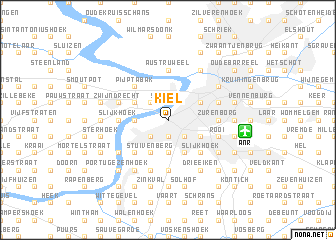
Kiel (Antwerpen, Belgium)Kiel is a town in the Antwerpen region of Belgium. An overview map of the region around Kiel is displayed below.
regional and 3d topo map of Kiel, Belgium ::
Kiel airports ::
The nearest airport is ANR - Antwerp Deurne, located 5.5 km east of Kiel.
Other airports nearby include WOE - Woensdrecht (27.9 km north), BRU - Brussels Natl (Melsbroek) (34.0 km south), EIN - Eindhoven (74.5 km east), CRL - Charleroi Brussels South (82.6 km south), Nearby towns ::
Sint-Anna (1.9km north) //
Hondsnest (1.9km south) //
Vinkenhoek (1.9km south) //
Vlaams Hoofd (2.2km north west) //
De Veren (2.2km south west) //
Heide (2.2km south west) //
Zwaantjes (2.2km south west) //
Kruishoek (2.2km south east) //
Nachtegaalshoek (2.2km south east) //
ʼt Hoeksken (2.3km west) //
Burcht (2.3km west) //
Biest (3.7km south) //
Duivelshoek (3.7km south) //
Stuivenberg (3.9km south) //
Het Vliet (3.0km north west) //
Heidam (3.0km north west) //
Kerkeveld (3.9km south) //
Wilrijk (3.9km south) //
Antwerpen (3.0km north east) //
Molenveld (3.0km south east) //
Oosterveld (3.0km south east) //
Pijp Tabak (4.4km north west) //
Hoboken (4.4km south west) //
Eikelbos (4.4km south east) //
Slijkhoek (4.4km south east) //
Austruweel (5.6km north) //
Zurenborg (3.5km east) //
Berchem (3.5km east) //
Slijkhoek (3.5km west) //
[all distances 'as the bird flies' and approximate]  Places with similar names to Kiel, Belgium ::
Disclaimer :: Information on this page comes without warranty of any kind |
||
|
Where is Kiel? Elevation and coordinates ::
Latitude (lat): 51°12'0"N Longitude (lon): 4°23'0"E
Elevation (approx.): 2m (map arrows pan, magnifying glasses zoom) |
||
|
Visiting Kiel? Hotel/Accommodation ::
Book a hotel in Kiel Travel Guide ::
Buy a travel guide for Belgium rental cars ::
car rental offers GPS waypoint ::
download a GPX waypoint (PoI) of Kiel for your GPS receiver
|
||