|
search place name
|
||
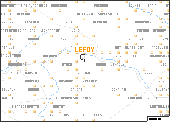
Le Foy (Luxembourg, Belgium)Le Foy is a town in the Luxembourg region of Belgium. An overview map of the region around Le Foy is displayed below.
regional and 3d topo map of Le Foy, Belgium ::
Le Foy airports ::
The nearest airport is LGG - Liege, located 52.8 km north of Le Foy.
Other airports nearby include CRL - Charleroi Brussels South (71.6 km north west), LUX - Luxemburg Luxembourg (86.3 km south east), MST - Maastricht (88.1 km north), SPM - Spangdahlem Ab (98.5 km east), Nearby towns ::
Chavanne (1.9km north) //
Hédrée (1.9km north) //
Harsin (1.9km north) //
Al Bèyoûle (1.2km west) //
Devant-Hedrée (2.2km north east) //
Marengo (2.2km north west) //
Haie de Rovy (2.2km south west) //
Tchèton-Bouchi (2.2km south west) //
Nassogne (3.7km south) //
Jemeppe (3.0km north west) //
Hargimont (3.0km north west) //
Charneux (3.0km north east) //
Haie de Marloie (3.0km north east) //
Ambly (3.0km south west) //
Stoké (3.0km south west) //
Grune (3.0km south east) //
Marche-en-Famenne (3.9km north) //
Ins ès Prés (3.9km south) //
Marloie (4.4km north west) //
Les Clusères (5.6km south) //
Ins ès Mwinnis (5.6km south) //
Hollogne (5.6km north) //
Antiémont (4.0km north west) //
Leharjostet (4.0km north east) //
Waha (5.7km north) //
Champlon Famenne (5.7km north) //
Haie du Capitaine (5.7km south) //
Pré Lacroix (5.7km south) //
Masbourg (6.0km south west) //
[all distances 'as the bird flies' and approximate] 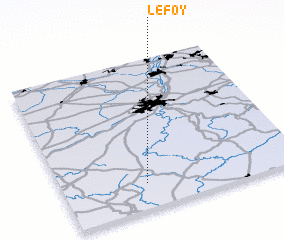 Places with similar names to Le Foy, Belgium ::
Disclaimer :: Information on this page comes without warranty of any kind |
||
|
Where is Le Foy? Elevation and coordinates ::
Latitude (lat): 50°10'0"N Longitude (lon): 5°21'0"E
Elevation (approx.): 278m (map arrows pan, magnifying glasses zoom) |
||
|
Visiting Le Foy? Hotel/Accommodation ::
Book a hotel in Le Foy Travel Guide ::
Buy a travel guide for Belgium rental cars ::
car rental offers GPS waypoint ::
download a GPX waypoint (PoI) of Le Foy for your GPS receiver
|
||