|
search place name
|
||
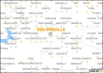
Philippeville (Namur, Belgium)Philippeville is a town in the Namur region of Belgium. An overview map of the region around Philippeville is displayed below.
regional and 3d topo map of Philippeville, Belgium ::
Philippeville airports ::
The nearest airport is CRL - Charleroi Brussels South, located 29.4 km north of Philippeville.
Other airports nearby include BRU - Brussels Natl (Melsbroek) (78.1 km north), LGG - Liege (80.9 km north east), RHE - Reims Champagne (104.9 km south), ANR - Antwerp Deurne (110.2 km north), Nearby towns ::
Vache Fontaine (0.0km north) //
Jamagne (1.9km north) //
Echerennes (1.2km east) //
Samart (1.9km south) //
Neuville (2.2km south west) //
La Reinette (3.7km north) //
Les Baraques (2.4km east) //
Saint-Lambert (3.9km north) //
Froidmont (3.9km north) //
Jamiolle (3.0km north west) //
Le Traigneaux (3.0km south west) //
La Tuwer (3.0km south east) //
La Botte (4.4km north west) //
Hemptinne (4.4km north east) //
Sautour (4.4km south east) //
Mon Plaisir (5.6km north) //
Vodecée (3.6km east) //
Le Coumagne (3.6km west) //
Trou des Fuyards (5.6km south) //
La Quersinelle (5.7km south) //
Villers-Deux-Églises (4.0km south west) //
Gomezée (5.1km north west) //
Yves-Gomezée (5.1km north west) //
Vieux-Sautour (5.1km south east) //
Terne Piron (6.0km south west) //
Le Fays (4.7km west) //
Marencheneux (4.7km west) //
Roly (7.4km south) //
Senzeille (5.1km west) //
[all distances 'as the bird flies' and approximate] 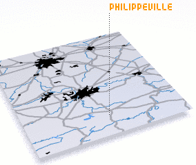 Places with similar names to Philippeville, Belgium ::
// Philippeville (BE)
Disclaimer :: Information on this page comes without warranty of any kind |
||
|
Where is Philippeville? Elevation and coordinates ::
Latitude (lat): 50°12'0"N Longitude (lon): 4°32'0"E
Elevation (approx.): 258m (map arrows pan, magnifying glasses zoom) |
||
|
Visiting Philippeville? Hotel/Accommodation ::
Book a hotel in Philippeville Travel Guide ::
Buy a travel guide for Belgium rental cars ::
car rental offers GPS waypoint ::
download a GPX waypoint (PoI) of Philippeville for your GPS receiver
|
||