|
search place name
|
||
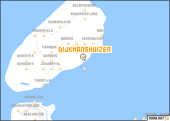
Dijkmanshuizen (Noord-Holland, Netherlands)Dijkmanshuizen is a town in the Noord-Holland region of Netherlands. An overview map of the region around Dijkmanshuizen is displayed below.
regional and 3d topo map of Dijkmanshuizen, Netherlands ::
Dijkmanshuizen airports ::
The nearest airport is DHR - De Kooy, located 15.2 km south of Dijkmanshuizen.
Other airports nearby include LWR - Leeuwarden (63.0 km east), AMS - Amsterdam Schiphol (82.8 km south), LID - Valkenburg (102.9 km south), UTC - Soesterberg (106.4 km south), Nearby towns ::
Oudeschild (1.9km south) //
Spang (2.2km north west) //
De Nes (3.7km north) //
Oosterend (3.9km north) //
Zevenhuizen (3.9km north) //
Nieuweschild (3.9km north) //
Noorderbuurt (3.9km north) //
Harkebuurt (3.9km north) //
Spijkdorp (3.9km north) //
Molenbuurt (3.9km north) //
Bargen (4.3km north west) //
Oude Schans (3.8km south west) //
Westergeest (3.8km south west) //
Hoogeberg (3.8km south west) //
De Waal (3.8km north west) //
Oost (6.0km north) //
Den Burg (4.5km west) //
Zuidhaffel (4.8km south west) //
Ongeren (4.8km north west) //
Tienhoven (4.8km north west) //
Zuid-Eierland (8.1km north west) //
[all distances 'as the bird flies' and approximate]  Places with similar names to Dijkmanshuizen, Netherlands :: Disclaimer :: Information on this page comes without warranty of any kind |
||
|
Where is Dijkmanshuizen? Elevation and coordinates ::
Latitude (lat): 53°3'0"N Longitude (lon): 4°52'0"E
Elevation (approx.): -32768m (map arrows pan, magnifying glasses zoom) |
||
|
Visiting Dijkmanshuizen? Hotel/Accommodation ::
Book a hotel in Dijkmanshuizen Travel Guide ::
Buy a travel guide for Netherlands rental cars ::
car rental offers GPS waypoint ::
download a GPX waypoint (PoI) of Dijkmanshuizen for your GPS receiver
|
||