|
search place name
|
||
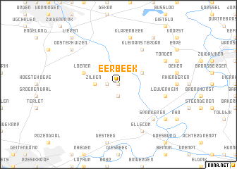
Eerbeek (Gelderland, Netherlands)Eerbeek is a town in the Gelderland region of Netherlands. An overview map of the region around Eerbeek is displayed below.
regional and 3d topo map of Eerbeek, Netherlands ::
Eerbeek airports ::
The nearest airport is UTC - Soesterberg, located 54.2 km west of Eerbeek.
Other airports nearby include ENS - Enschede Twenthe (58.4 km east), EIN - Eindhoven (86.7 km south west), AMS - Amsterdam Schiphol (92.0 km west), ESS - Essen Mulheim (98.2 km south east), Nearby towns ::
Wilhelminapark (0.0km north) //
Coldenhove (1.1km west) //
Laag-Soeren (1.9km south) //
Zilven (2.3km west) //
Hall (2.9km north east) //
Loenen (3.9km north west) //
Klein Amsterdam (6.0km north) //
Leuvenheim (4.9km east) //
Klarenbeek (7.5km north) //
Spankeren (6.5km south east) //
Tonden (5.9km north east) //
Ellecom (7.8km south) //
Dieren (7.2km south east) //
Olburgen (7.2km south east) //
Oosterhuizen (7.2km north west) //
Noord-Empe (8.2km north east) //
Lieren (8.7km north west) //
[all distances 'as the bird flies' and approximate] 
Disclaimer :: Information on this page comes without warranty of any kind |
||
|
Where is Eerbeek? Elevation and coordinates ::
Latitude (lat): 52°6'0"N Longitude (lon): 6°4'0"E
Elevation (approx.): 23m (map arrows pan, magnifying glasses zoom) |
||
|
Visiting Eerbeek? Hotel/Accommodation ::
Book a hotel in Eerbeek Travel Guide ::
Buy a travel guide for Netherlands rental cars ::
car rental offers GPS waypoint ::
download a GPX waypoint (PoI) of Eerbeek for your GPS receiver
|
||