|
search place name
|
||
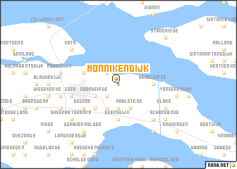
Monnikendijk (Zeeland, Netherlands)Monnikendijk is a town in the Zeeland region of Netherlands. An overview map of the region around Monnikendijk is displayed below.
regional and 3d topo map of Monnikendijk, Netherlands ::
Monnikendijk airports ::
The nearest airport is WOE - Woensdrecht, located 28.3 km east of Monnikendijk.
Other airports nearby include ANR - Antwerp Deurne (50.9 km south east), RTM - Rotterdam (59.4 km north east), BRU - Brussels Natl (Melsbroek) (78.0 km south east), LID - Valkenburg (79.1 km north east), Nearby towns ::
Kattendijke (0.0km north) //
Goessche Sas (2.2km north west) //
Tervaten (2.2km south west) //
Waanskinderen (2.2km south west) //
Biezelinge (3.7km south) //
Noordeinde (3.0km south west) //
Kloetinge (3.0km south west) //
Dijkwel (3.9km south) //
Maalstede (3.9km south) //
Abbekinderen (4.4km south west) //
Wemeldinge (3.5km east) //
Eversdijk (5.6km south) //
Wilhelminadorp (3.9km north west) //
De Groe (5.1km south west) //
Goes (5.0km west) //
Schore (6.5km south east) //
Vlake (5.9km south east) //
Kats (7.2km north west) //
Hansweert (8.2km south east) //
ʼs-Gravenpolder (8.2km south west) //
Schorebrug (7.2km south east) //
ʼs-Heer-Abtskerke (7.2km south west) //
Stavenisse (8.7km north east) //
[all distances 'as the bird flies' and approximate]  Places with similar names to Monnikendijk, Netherlands ::
// Monkendjoko (GA)
Disclaimer :: Information on this page comes without warranty of any kind |
||
|
Where is Monnikendijk? Elevation and coordinates ::
Latitude (lat): 51°31'0"N Longitude (lon): 3°57'0"E
Elevation (approx.): -3m (map arrows pan, magnifying glasses zoom) |
||
|
Visiting Monnikendijk? Hotel/Accommodation ::
Book a hotel in Monnikendijk Travel Guide ::
Buy a travel guide for Netherlands rental cars ::
car rental offers GPS waypoint ::
download a GPX waypoint (PoI) of Monnikendijk for your GPS receiver
|
||