|
search place name
|
||
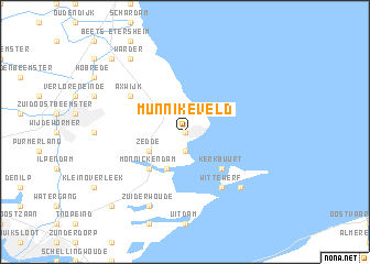
Munnikeveld (Noord-Holland, Netherlands)Munnikeveld is a town in the Noord-Holland region of Netherlands. An overview map of the region around Munnikeveld is displayed below.
regional and 3d topo map of Munnikeveld, Netherlands ::
Munnikeveld airports ::
The nearest airport is AMS - Amsterdam Schiphol, located 29.6 km south west of Munnikeveld.
Other airports nearby include UTC - Soesterberg (43.9 km south), DHR - De Kooy (50.9 km north), LID - Valkenburg (57.8 km south west), RTM - Rotterdam (74.2 km south west), Nearby towns ::
Volendam (0.0km north) //
Katham (1.9km south) //
Singelwijk (2.2km north west) //
Edam (2.2km north west) //
Katwoude (3.9km south) //
Zedde (2.9km south west) //
Kerkbuurt (4.3km south east) //
Monnickendam (4.3km south west) //
Havenbuurt (6.0km south) //
Wittewerf (6.0km south) //
Middelie (5.0km north west) //
Axwijk (5.0km north west) //
Moeniswerf (6.5km south east) //
Rozewerf (6.5km south east) //
Zuiderwoude (7.7km south) //
Warder (8.1km north west) //
Broek in Waterland (8.7km south west) //
Oosthuizen (8.7km north west) //
[all distances 'as the bird flies' and approximate] 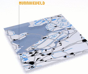 Places with similar names to Munnikeveld, Netherlands :: Disclaimer :: Information on this page comes without warranty of any kind |
||
|
Where is Munnikeveld? Elevation and coordinates ::
Latitude (lat): 52°30'0"N Longitude (lon): 5°4'0"E
Elevation (approx.): -1m (map arrows pan, magnifying glasses zoom) |
||
|
Visiting Munnikeveld? Hotel/Accommodation ::
Book a hotel in Munnikeveld Travel Guide ::
Buy a travel guide for Netherlands rental cars ::
car rental offers GPS waypoint ::
download a GPX waypoint (PoI) of Munnikeveld for your GPS receiver
|
||