|
search place name
|
||
Nieuwebrug (Friesland, Netherlands)Nieuwebrug is a town in the Friesland region of Netherlands. An overview map of the region around Nieuwebrug is displayed below.
regional and 3d topo map of Nieuwebrug, Netherlands ::

Nieuwebrug airports ::
The nearest airport is LWR - Leeuwarden, located 26.7 km north of Nieuwebrug.
Other airports nearby include GRQ - Groningen Eelde (48.5 km east), DHR - De Kooy (74.6 km west), BMK - Borkum (86.2 km north east), EME - Emden (99.8 km north east), Nearby towns ::
Haskerdijken (1.1km west) //
Vegelinsoord (1.1km west) //
Spitsendijk (2.2km east) //
Lekkerterp (3.9km north) //
Nijehaske (3.9km south) //
Luinjeberd (2.9km south east) //
Terband (2.9km south east) //
Sijthuizen (4.3km north west) //
Oudehaske (5.7km south) //
Oldeboorn (5.7km north) //
Nes (6.0km north) //
De Greiden (6.0km south) //
Tjalleberd (4.5km east) //
Sorremorre (7.5km north) //
Rottum (7.5km south) //
Oosterboorn (6.5km north east) //
Heerenveen (6.5km south east) //
Haskerhorne (6.5km south west) //
Akkrum (6.5km north west) //
Onland (7.7km south) //
Birstum (7.7km north) //
Rotsterhaule (7.7km south) //
Poppenhuizen (7.7km north) //
Nieuweschoot (8.1km south east) //
Warniahuizen (8.1km north east) //
Ouwsterhaule (8.7km south west) //
Oude Schouw (8.7km north west) //
[all distances 'as the bird flies' and approximate] 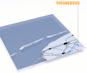 Places with similar names to Nieuwebrug, Netherlands ::
Disclaimer :: Information on this page comes without warranty of any kind |
||
|
Where is Nieuwebrug? Elevation and coordinates ::
Latitude (lat): 53°0'0"N Longitude (lon): 5°53'0"E
Elevation (approx.): -1m (map arrows pan, magnifying glasses zoom) |
||
|
Visiting Nieuwebrug? Hotel/Accommodation ::
Book a hotel in Nieuwebrug Travel Guide ::
Buy a travel guide for Netherlands rental cars ::
car rental offers GPS waypoint ::
download a GPX waypoint (PoI) of Nieuwebrug for your GPS receiver
|
||