|
search place name
|
||
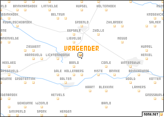
Vragender (Gelderland, Netherlands)Vragender is a town in the Gelderland region of Netherlands. An overview map of the region around Vragender is displayed below.
regional and 3d topo map of Vragender, Netherlands ::
Vragender airports ::
The nearest airport is ENS - Enschede Twenthe, located 36.4 km north east of Vragender.
Other airports nearby include ESS - Essen Mulheim (68.3 km south), FMO - Muenster/osnabrueck Munster Osnabruck (75.2 km east), DUS - Duesseldorf Dusseldorf (77.9 km south), MGL - Moenchengladbach Monchengladbach (84.1 km south), Nearby towns ::
Barlo (2.2km south west) //
Groot Deunk (2.2km south west) //
Bredevoort (3.7km south) //
Hollenberg (3.9km south) //
Lievelde (3.9km north) //
Miste (4.4km south east) //
Lichtenvoorde (3.4km west) //
Corle (3.9km south east) //
Eefsele (5.7km north) //
ʼt Velleken (5.0km south west) //
Dale (5.0km south west) //
Zwolle (6.0km north) //
Aalten (6.0km south) //
Groenlo (7.4km north) //
Haart (7.5km south) //
Brinke (5.9km south east) //
Blekkink (8.2km south east) //
Zwilbroek (8.7km north east) //
[all distances 'as the bird flies' and approximate] 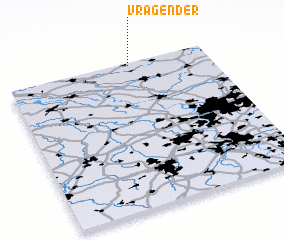 Places with similar names to Vragender, Netherlands ::
// Ferg Īnder (ET)
Disclaimer :: Information on this page comes without warranty of any kind |
||
|
Where is Vragender? Elevation and coordinates ::
Latitude (lat): 51°59'0"N Longitude (lon): 6°37'0"E
Elevation (approx.): 33m (map arrows pan, magnifying glasses zoom) |
||
|
Visiting Vragender? Hotel/Accommodation ::
Book a hotel in Vragender Travel Guide ::
Buy a travel guide for Netherlands rental cars ::
car rental offers GPS waypoint ::
download a GPX waypoint (PoI) of Vragender for your GPS receiver
|
||