|
search place name
|
||
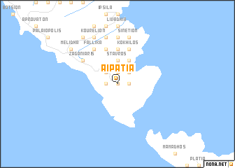
Aïpátia (Piraiévs, Greece)Aïpátia is a town in the Piraiévs region of Greece. An overview map of the region around Aïpátia is displayed below.
regional and 3d topo map of Aïpátia, Greece ::
Aïpátia airports ::
The nearest airport is JMK - Mykonos Mikonos, located 50.6 km south east of Aïpátia.
Other airports nearby include JKH - Chios (124.8 km north east), SKU - Skiros (140.7 km north), JTR - Santorini (157.6 km south), SMI - Samos (174.5 km east), Nearby towns ::
Píso Meriá (0.0km north) //
Piskopiá (1.5km west) //
Amonakliós (1.5km east) //
Aïdhónia (1.5km east) //
Mousiónas (1.5km east) //
Alamanniá (1.9km north) //
Kórthion (1.9km north) //
Kappariá (2.4km north west) //
Episkopión (2.4km north west) //
Khónai (2.4km north east) //
Órmos (2.4km north east) //
Stavrós (3.7km north) //
Rogón (4.0km north) //
Mésa Vouníon (5.6km north) //
Péra Khorió (5.7km north) //
Kókhilos (5.7km north) //
Orinón (6.3km north west) //
Fállika (6.3km north west) //
Zaganiáris (5.7km north west) //
Vrakhnós (7.4km north) //
Mesariá (7.6km north) //
Sinétion (7.6km north) //
Ménites (8.0km north) //
Kourélion (8.0km north) //
Melídha (8.1km north west) //
Pitrofós (8.6km north west) //
Aladhinón (8.6km north west) //
[all distances 'as the bird flies' and approximate]  Places with similar names to Aïpátia, Greece ::
Disclaimer :: Information on this page comes without warranty of any kind |
||
|
Where is Aïpátia? Elevation and coordinates ::
Latitude (lat): 37°45'0"N Longitude (lon): 24°56'0"E
Elevation (approx.): 232m (map arrows pan, magnifying glasses zoom) |
||
|
Visiting Aïpátia? Hotel/Accommodation ::
Book a hotel in Aïpátia Travel Guide ::
Buy a travel guide for Greece rental cars ::
car rental offers GPS waypoint ::
download a GPX waypoint (PoI) of Aïpátia for your GPS receiver
|
||