|
search place name
|
||
Ambelófiton (Piraiévs, Greece)Ambelófiton is a town in the Piraiévs region of Greece. An overview map of the region around Ambelófiton is displayed below.
regional and 3d topo map of Ambelófiton, Greece ::

Ambelófiton airports ::
The nearest airport is KLX - Kalamata, located 29.0 km east of Ambelófiton.
Other airports nearby include PYR - Andravida (103.1 km north), ZTH - Zakynthos Dionysios Solomos (106.1 km north west), GPA - Patras Araxos (124.6 km north), KIT - Kithira (145.9 km south east), Nearby towns ::
Pírgos (1.9km north) //
Khóra (1.5km east) //
Lévki (3.0km west) //
Plátanos (4.7km south east) //
Mirsinokhórion (4.7km south east) //
Flóka (4.7km north west) //
Korifásion (5.8km south) //
Pisáskion (5.8km south) //
Íklaina (5.8km south) //
Stilianós (4.8km north east) //
Mouzákion (5.8km north) //
Romanós (6.3km south west) //
Tragána (6.3km south west) //
Pappoúlia (5.8km south east) //
Metamórfosis (5.9km east) //
Elaiófiton (7.6km south) //
Gargaliánoi (6.2km west) //
Glifádha (7.1km south east) //
Metaxádha (7.1km north east) //
Vromonérion (7.0km south west) //
Petrokhórion (8.0km south) //
Maniákion (7.0km north east) //
Stavrós (8.0km north) //
Flesiás (8.1km north east) //
Válta (8.1km north west) //
Káto Kremmídhia (9.5km south east) //
Palaión Loutrón (9.5km north east) //
[all distances 'as the bird flies' and approximate] 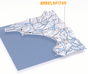 Places with similar names to Ambelófiton, Greece :: Disclaimer :: Information on this page comes without warranty of any kind |
||
|
Where is Ambelófiton? Elevation and coordinates ::
Latitude (lat): 37°3'0"N Longitude (lon): 21°42'0"E
Elevation (approx.): 181m (map arrows pan, magnifying glasses zoom) |
||
|
Visiting Ambelófiton? Hotel/Accommodation ::
Book a hotel in Ambelófiton Travel Guide ::
Buy a travel guide for Greece rental cars ::
car rental offers GPS waypoint ::
download a GPX waypoint (PoI) of Ambelófiton for your GPS receiver
|
||