|
search place name
|
||
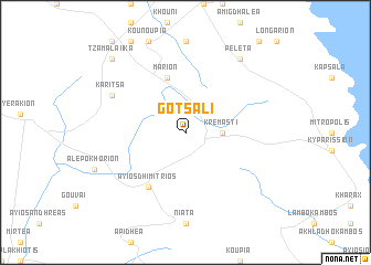
Gótsali (Piraiévs, Greece)Gótsali is a town in the Piraiévs region of Greece. An overview map of the region around Gótsali is displayed below.
regional and 3d topo map of Gótsali, Greece ::
Gótsali airports ::
The nearest airport is KLX - Kalamata, located 74.0 km west of Gótsali.
Other airports nearby include KIT - Kithira (80.1 km south), PYR - Andravida (172.7 km north west), GPA - Patras Araxos (180.6 km north west), ZTH - Zakynthos Dionysios Solomos (193.8 km north west), Nearby towns ::
Kremastí (3.0km east) //
Márion (5.8km north) //
Áyios Dhimítrios (6.3km south west) //
Karítsa (7.0km north west) //
Peletá (8.6km north east) //
Tzamalaíika (9.5km north west) //
[all distances 'as the bird flies' and approximate]  Places with similar names to Gótsali, Greece ::
// Kaid Salah (MA)
// Ca di Sola (IT)
// Catasol (PT)
// Kutsala (EE)
// Gutsal (BG)
// Cotu Iazului (RO)
// Güdüşlü (TR)
// Codesal (ES)
// Kādisāl (BD)
// Catesal (CO)
Disclaimer :: Information on this page comes without warranty of any kind |
||
|
Where is Gótsali? Elevation and coordinates ::
Latitude (lat): 36°59'0"N Longitude (lon): 22°51'0"E
Elevation (approx.): 888m (map arrows pan, magnifying glasses zoom) |
||
|
Visiting Gótsali? Hotel/Accommodation ::
Book a hotel in Gótsali Travel Guide ::
Buy a travel guide for Greece rental cars ::
car rental offers GPS waypoint ::
download a GPX waypoint (PoI) of Gótsali for your GPS receiver
|
||