|
search place name
|
||
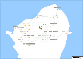
Kinídharos (Piraiévs, Greece)Kinídharos is a town in the Piraiévs region of Greece. An overview map of the region around Kinídharos is displayed below.
regional and 3d topo map of Kinídharos, Greece ::
Kinídharos airports ::
The nearest airport is JMK - Mykonos Mikonos, located 39.1 km north of Kinídharos.
Other airports nearby include JTR - Santorini (77.8 km south), LRS - Leros (117.4 km east), SMI - Samos (142.4 km north east), KGS - Kos (147.2 km east), Nearby towns ::
Moní (2.4km south east) //
Khalkíon (3.7km south) //
Tsikkalarión (4.0km south) //
Akádhimoi (4.0km south) //
Keramotí (3.5km north east) //
Áno Potamiá (4.7km south west) //
Apérathos (4.7km south east) //
Mélanes (4.4km west) //
Dhamariónas (5.6km south) //
Faneroméni (5.8km north) //
Moutsoúna (4.8km south east) //
Kóronos (4.8km north east) //
Skadhón (4.8km north east) //
Engaraí (4.8km north west) //
Filótion (5.8km south) //
Káto Potamiá (5.8km south west) //
Galanádhon (6.2km west) //
Galíni (6.2km west) //
Koronís (7.1km north east) //
Dhanakós (7.1km south east) //
Mési (8.1km north east) //
Káto Sangríon (8.6km south west) //
Áno Sangríon (8.6km south west) //
[all distances 'as the bird flies' and approximate]  Places with similar names to Kinídharos, Greece :: Disclaimer :: Information on this page comes without warranty of any kind |
||
|
Where is Kinídharos? Elevation and coordinates ::
Latitude (lat): 37°6'0"N Longitude (lon): 25°29'0"E
Elevation (approx.): 400m (map arrows pan, magnifying glasses zoom) |
||
|
Visiting Kinídharos? Hotel/Accommodation ::
Book a hotel in Kinídharos Travel Guide ::
Buy a travel guide for Greece rental cars ::
car rental offers GPS waypoint ::
download a GPX waypoint (PoI) of Kinídharos for your GPS receiver
|
||