|
search place name
|
||
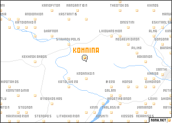
Komniná (Piraiévs, Greece)Komniná is a town in the Piraiévs region of Greece. An overview map of the region around Komniná is displayed below.
regional and 3d topo map of Komniná, Greece ::
Komniná airports ::
The nearest airport is KVA - Kavala Megas Alexandros Intl, located 29.7 km south of Komniná.
Other airports nearby include PDV - Plovdiv (100.6 km north), AXD - Alexandroupolis Dimokritos (108.5 km east), LXS - Limnos (145.2 km south), SKG - Thessaloniki Makedonia (165.1 km south west), Nearby towns ::
Kromnikón (3.7km south) //
Stavroúpolis (4.6km north west) //
Áno Liverá (4.6km south west) //
Káto Liverá (6.2km south west) //
Likodhrómion (7.0km north east) //
Ímera (7.0km south east) //
Dhafnón (7.9km north west) //
Galáni (8.5km south east) //
Kriós (7.9km north east) //
Seméli (9.3km south east) //
Ayéli (9.3km south east) //
Petrotón (9.3km south east) //
[all distances 'as the bird flies' and approximate] 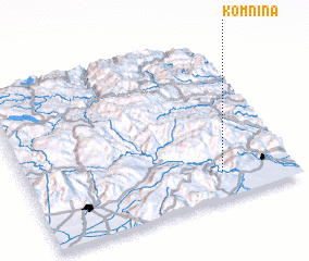 Places with similar names to Komniná, Greece ::
// Camannauan (PH)
// Guimbunan (PH)
// Komnino (PL)
// Komunin (PL)
// Komunin Nowy (PL)
// Comunión (ES)
// Ga-Monene (ZA)
// Gomnino (RU)
// Kamanino (RU)
// Kamynino (RU)
Disclaimer :: Information on this page comes without warranty of any kind |
||
|
Where is Komniná? Elevation and coordinates ::
Latitude (lat): 41°10'0"N Longitude (lon): 24°44'0"E
Elevation (approx.): 267m (map arrows pan, magnifying glasses zoom) |
||
|
Visiting Komniná? Hotel/Accommodation ::
Book a hotel in Komniná Travel Guide ::
Buy a travel guide for Greece rental cars ::
car rental offers GPS waypoint ::
download a GPX waypoint (PoI) of Komniná for your GPS receiver
|
||