|
search place name
|
||
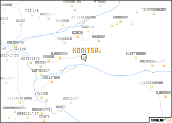
Kónitsa (Ioánnina, Greece)Kónitsa is a town in the Ioánnina region of Greece. An overview map of the region around Kónitsa is displayed below.
regional and 3d topo map of Kónitsa, Greece ::
Kónitsa airports ::
The nearest airport is IOA - Ioannina, located 39.5 km south of Kónitsa.
Other airports nearby include KSO - Kastoria Aristotelis (62.8 km north east), CFU - Kerkyra/corfu Ioannis Kapodistrias Intl (87.7 km south west), KZI - Kozani Filippos (96.0 km east), PVK - Preveza Aktio (124.7 km south), Nearby towns ::
Synoikismós Pigís (2.2km north west) //
Pigí (3.2km north east) //
Nikánor (4.9km north east) //
Exochí (5.6km north) //
Iliórrachi (4.5km west) //
Kavásila (5.5km north west) //
Trápeza (6.7km north) //
(( Róngia )) (6.2km west) //
Kallithéa (7.3km south west) //
(( Ágios Geórgios )) (8.7km north) //
Monastírion (8.8km north east) //
Pyxariá (9.0km north west) //
Mólista (9.8km north east) //
Ganadión (10.5km north east) //
Kleidoniá (10.8km south west) //
[all distances 'as the bird flies' and approximate] 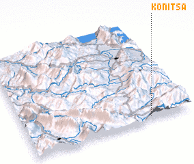 Places with similar names to Kónitsa, Greece ::
Disclaimer :: Information on this page comes without warranty of any kind |
||
|
Where is Kónitsa? Elevation and coordinates ::
Latitude (lat): 40°2'55"N Longitude (lon): 20°45'24"E
Elevation (approx.): 706m (map arrows pan, magnifying glasses zoom) |
||
|
Visiting Kónitsa? Hotel/Accommodation ::
Book a hotel in Kónitsa Travel Guide ::
Buy a travel guide for Greece rental cars ::
car rental offers GPS waypoint ::
download a GPX waypoint (PoI) of Kónitsa for your GPS receiver
|
||