|
search place name
|
||
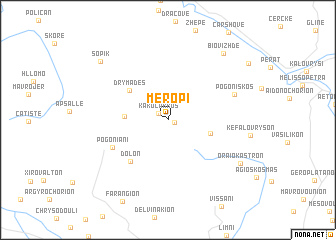
Merópi (Ioánnina, Greece)Merópi is a town in the Ioánnina region of Greece. An overview map of the region around Merópi is displayed below.
regional and 3d topo map of Merópi, Greece ::
Merópi airports ::
The nearest airport is IOA - Ioannina, located 47.3 km south east of Merópi.
Other airports nearby include CFU - Kerkyra/corfu Ioannis Kapodistrias Intl (68.0 km south west), KSO - Kastoria Aristotelis (82.4 km north east), KZI - Kozani Filippos (119.4 km east), PVK - Preveza Aktio (125.1 km south), Nearby towns ::
Palaiópyrgos (0.6km south east) //
Kakólakkos (1.1km north west) //
Stavroskiádion (3.8km west) //
Káto Merópi (3.9km east) //
Drymádes (4.6km north west) //
Dolón (5.7km south west) //
Pogonianí (5.6km south west) //
Pogonískos (6.3km north east) //
Oraiókastron (7.9km south east) //
Biovizhdë (8.8km north east) //
Sopik (8.7km north west) //
[all distances 'as the bird flies' and approximate] 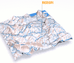 Places with similar names to Merópi, Greece ::
Disclaimer :: Information on this page comes without warranty of any kind |
||
|
Where is Merópi? Elevation and coordinates ::
Latitude (lat): 40°1'49"N Longitude (lon): 20°28'48"E
Elevation (approx.): 873m (map arrows pan, magnifying glasses zoom) |
||
|
Visiting Merópi? Hotel/Accommodation ::
Book a hotel in Merópi Travel Guide ::
Buy a travel guide for Greece rental cars ::
car rental offers GPS waypoint ::
download a GPX waypoint (PoI) of Merópi for your GPS receiver
|
||