|
search place name
|
||
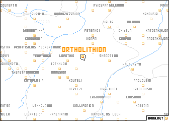
Ortholíthion (Piraiévs, Greece)Ortholíthion is a town in the Piraiévs region of Greece. An overview map of the region around Ortholíthion is displayed below.
regional and 3d topo map of Ortholíthion, Greece ::
Ortholíthion airports ::
The nearest airport is GPA - Patras Araxos, located 53.0 km west of Ortholíthion.
Other airports nearby include PYR - Andravida (65.2 km west), AGQ - Agrinion (84.5 km north west), ZTH - Zakynthos Dionysios Solomos (105.0 km west), KLX - Kalamata (109.0 km south), Nearby towns ::
Famelítika (2.4km north east) //
Vrisárion (2.4km north east) //
Dhrosáton (2.4km north east) //
Flámboura (2.4km south west) //
Lapáthia (2.9km west) //
Korfaí (4.0km north) //
Krionérion (4.7km south west) //
Skepastón (4.4km east) //
Petsákoi (5.7km north) //
Trekhlón (4.8km south west) //
Koúteli (5.7km south) //
Manésion (5.7km south west) //
Boúmboukas (5.7km south west) //
Kértezi (7.6km south) //
Mégas Pondiás (6.1km west) //
Krastikoí (8.6km south east) //
Lapanayoí (8.6km north west) //
Válta (8.6km north east) //
Spartinoú (9.4km north east) //
Plataniótissa (9.4km north east) //
[all distances 'as the bird flies' and approximate]  Places with similar names to Ortholíthion, Greece :: Disclaimer :: Information on this page comes without warranty of any kind |
||
|
Where is Ortholíthion? Elevation and coordinates ::
Latitude (lat): 38°3'0"N Longitude (lon): 22°1'0"E
Elevation (approx.): 716m (map arrows pan, magnifying glasses zoom) |
||
|
Visiting Ortholíthion? Hotel/Accommodation ::
Book a hotel in Ortholíthion Travel Guide ::
Buy a travel guide for Greece rental cars ::
car rental offers GPS waypoint ::
download a GPX waypoint (PoI) of Ortholíthion for your GPS receiver
|
||