|
search place name
|
||
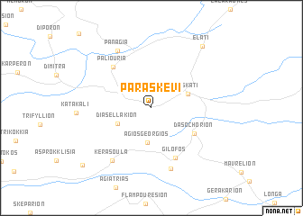
Paraskeví (Grevená, Greece)Paraskeví is a town in the Grevená region of Greece. An overview map of the region around Paraskeví is displayed below.
regional and 3d topo map of Paraskeví, Greece ::
Paraskeví airports ::
The nearest airport is KZI - Kozani Filippos, located 42.7 km north of Paraskeví.
Other airports nearby include LRA - Larissa Larisa (66.6 km south east), KSO - Kastoria Aristotelis (72.5 km north west), IOA - Ioannina (83.8 km west), VOL - Nea Anghialos Nea Anchialos (117.0 km south east), Nearby towns ::
Ágios Geórgios (4.3km south) //
Diasellákion (3.8km south west) //
Deskáti (3.9km north east) //
Dasochórion (5.2km south east) //
Paliouriá (6.2km north west) //
Gílofos (6.6km south) //
Foteinón (7.8km south) //
Kerasoúla (7.6km south west) //
Panagía (7.8km north west) //
Eláti (9.1km north east) //
Psíloma (9.6km south west) //
[all distances 'as the bird flies' and approximate] 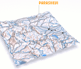 Places with similar names to Paraskeví, Greece ::
// Paraskeví (GR)
// Pärsikivi (EE)
// Porskovo (EE)
// Pîrscov (RO)
// Perrys Cove (CA)
// (( Pirozhkov )) (RU)
// Pirozhkov (RU)
// Pirozhkovo (RU)
// Pirozhkovo (RU)
// Pirozhkovo (RU)
Disclaimer :: Information on this page comes without warranty of any kind |
||
|
Where is Paraskeví? Elevation and coordinates ::
Latitude (lat): 39°54'24"N Longitude (lon): 21°45'44"E
Elevation (approx.): 732m (map arrows pan, magnifying glasses zoom) |
||
|
Visiting Paraskeví? Hotel/Accommodation ::
Book a hotel in Paraskeví Travel Guide ::
Buy a travel guide for Greece rental cars ::
car rental offers GPS waypoint ::
download a GPX waypoint (PoI) of Paraskeví for your GPS receiver
|
||