|
search place name
|
||
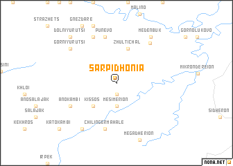
Sarpidhonía (Piraiévs, Greece)Sarpidhonía is a town in the Piraiévs region of Greece. An overview map of the region around Sarpidhonía is displayed below.
regional and 3d topo map of Sarpidhonía, Greece ::
Sarpidhonía airports ::
The nearest airport is AXD - Alexandroupolis Dimokritos, located 49.4 km south of Sarpidhonía.
Other airports nearby include KVA - Kavala Megas Alexandros Intl (122.4 km west), PDV - Plovdiv (127.1 km north west), LXS - Limnos (166.1 km south west), BOJ - Bourgas Burgas (189.8 km north east), Nearby towns ::
Arkhondokhóri (1.9km south) //
Mesimérion (3.7km south) //
Kissós (4.6km south west) //
Mikrákion (4.6km south west) //
Zhŭlti Chal (5.7km north) //
Chilingér Mahalé (7.5km south) //
Pŭnevo (7.5km north) //
Áno Kambí (6.7km south west) //
Bezhantsi (7.9km north) //
Cherna Cherkva (7.6km north east) //
Gorni Yurutsi (7.9km north west) //
Álikon (8.5km south west) //
Meden Buk (8.5km north east) //
Dolni Yurutsi (9.3km north west) //
[all distances 'as the bird flies' and approximate] 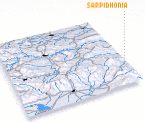 Places with similar names to Sarpidhonía, Greece ::
// Siripidhianá (GR)
Disclaimer :: Information on this page comes without warranty of any kind |
||
|
Where is Sarpidhonía? Elevation and coordinates ::
Latitude (lat): 41°18'0"N Longitude (lon): 25°59'0"E
Elevation (approx.): 472m (map arrows pan, magnifying glasses zoom) |
||
|
Visiting Sarpidhonía? Hotel/Accommodation ::
Book a hotel in Sarpidhonía Travel Guide ::
Buy a travel guide for Greece rental cars ::
car rental offers GPS waypoint ::
download a GPX waypoint (PoI) of Sarpidhonía for your GPS receiver
|
||