|
search place name
|
||
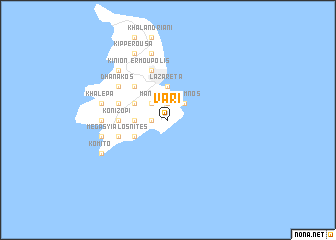
Vári (Piraiévs, Greece)Vári is a town in the Piraiévs region of Greece. An overview map of the region around Vári is displayed below.
regional and 3d topo map of Vári, Greece ::
Vári airports ::
The nearest airport is JMK - Mykonos Mikonos, located 35.5 km east of Vári.
Other airports nearby include JTR - Santorini (120.7 km south east), JKH - Chios (148.1 km north east), LRS - Leros (165.8 km east), SMI - Samos (176.3 km east), Nearby towns ::
Perdhíki (1.5km west) //
Kouroúpi (1.9km north) //
Mánna (2.4km north west) //
Azólimnos (2.4km north east) //
Khroúsa (2.9km west) //
Lazaréta (3.7km north) //
Liaropá (3.5km south west) //
Firókambos (3.5km north west) //
Tálanda (4.7km north west) //
Episkopíon (4.7km north west) //
Konizopí (4.4km west) //
Mégas Yialós-Nítes (4.8km south west) //
Mesariá (4.8km north west) //
Págos (4.8km north west) //
Parakopí (4.8km north west) //
Agrós (4.8km north west) //
Ermoúpolis (5.8km north) //
Áno Síros (5.8km north) //
Dhanakós (5.8km north west) //
Foínix (5.9km west) //
Víssa (5.9km west) //
Foiníkia (7.6km north) //
Galissás (6.2km west) //
Posidhonía (6.2km west) //
Khalépa (6.2km west) //
Kínion (7.1km north west) //
Kómito (7.0km south west) //
Kipperoúsa (8.0km north) //
Plátos (8.0km north) //
[all distances 'as the bird flies' and approximate]  Places with similar names to Vári, Greece ::
Disclaimer :: Information on this page comes without warranty of any kind |
||
|
Where is Vári? Elevation and coordinates ::
Latitude (lat): 37°24'0"N Longitude (lon): 24°57'0"E
Elevation (approx.): 32m (map arrows pan, magnifying glasses zoom) |
||
|
Visiting Vári? Hotel/Accommodation ::
Book a hotel in Vári Travel Guide ::
Buy a travel guide for Greece rental cars ::
car rental offers GPS waypoint ::
download a GPX waypoint (PoI) of Vári for your GPS receiver
|
||