|
search place name
|
||
Cerro Ruivo (Faro, Portugal)Cerro Ruivo is a town in the Faro region of Portugal. An overview map of the region around Cerro Ruivo is displayed below.
regional and 3d topo map of Cerro Ruivo, Portugal ::

Cerro Ruivo airports ::
The nearest airport is FAO - Faro, located 65.5 km east of Cerro Ruivo.
Other airports nearby include LIS - Lisbon Lisboa (185.4 km north), BJZ - Badajoz Talavera La Real (253.1 km north east), Nearby towns ::
Sargaçal (1.9km south) //
Monte Ruivo (1.9km north) //
Caldeiroa (1.9km south) //
Torre (2.4km south east) //
Pedra Branca (2.4km north east) //
Pinheiral (2.4km south east) //
Cotifo de Cima (2.4km north west) //
São João (3.7km south) //
Ponte (3.7km south) //
Marateca (3.7km south) //
Odiáxere (3.0km east) //
Alfarrobeira (3.0km east) //
Ruivas (3.0km east) //
Albardeira (4.0km south) //
Caliças (4.0km south) //
Telheiro (4.0km south) //
Falfeira (4.0km south) //
Alto da Cerca (4.0km south) //
Portelas (4.0km south) //
Fonte Coberta (4.0km south) //
Arão (3.5km north east) //
Meia Praia (4.7km south east) //
Senhora da Glória (5.6km south) //
Santo Amaro (5.6km south) //
Bensafrim (4.4km west) //
Lagos (5.8km south) //
Quatro Estradas (5.8km south) //
Pedra Alçada (5.8km south) //
Vale da Lama (4.8km south east) //
[all distances 'as the bird flies' and approximate] 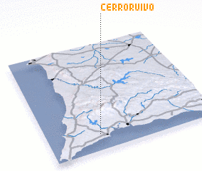 Places with similar names to Cerro Ruivo, Portugal ::
Disclaimer :: Information on this page comes without warranty of any kind |
||
|
Where is Cerro Ruivo? Elevation and coordinates ::
Latitude (lat): 37°9'0"N Longitude (lon): 8°41'0"W
Elevation (approx.): 44m (map arrows pan, magnifying glasses zoom) |
||
|
Visiting Cerro Ruivo? Hotel/Accommodation ::
Book a hotel in Cerro Ruivo Travel Guide ::
Buy a travel guide for Portugal rental cars ::
car rental offers GPS waypoint ::
download a GPX waypoint (PoI) of Cerro Ruivo for your GPS receiver
|
||