|
search place name
|
||
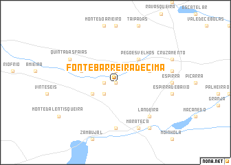
Fonte Barreira de Cima (Setúbal, Portugal)Fonte Barreira de Cima is a town in the Setúbal region of Portugal. An overview map of the region around Fonte Barreira de Cima is displayed below.
regional and 3d topo map of Fonte Barreira de Cima, Portugal ::
Fonte Barreira de Cima airports ::
The nearest airport is LIS - Lisbon Lisboa, located 40.6 km west of Fonte Barreira de Cima.
Other airports nearby include BJZ - Badajoz Talavera La Real (165.4 km east), FAO - Faro (192.7 km south), Nearby towns ::
Fonte Barreira de Baixo (0.0km north) //
Monte do Caria (0.0km north) //
Monte do Godinho (1.4km west) //
Pegos Claros (1.9km north) //
Monte Alegre (2.4km south west) //
Monte do José da Costa (3.4km south west) //
Pegões Velhos (4.7km north east) //
Somaria Nova (4.7km north east) //
Lagoa do Calvo (4.7km north west) //
Águas de Moura (7.4km south) //
Landeira (7.1km south east) //
Marateca (8.0km south) //
Quinta das Faias (6.9km north west) //
Ferrarias (8.6km south east) //
[all distances 'as the bird flies' and approximate]  Places with similar names to Fonte Barreira de Cima, Portugal :: Disclaimer :: Information on this page comes without warranty of any kind |
||
|
Where is Fonte Barreira de Cima? Elevation and coordinates ::
Latitude (lat): 38°39'0"N Longitude (lon): 8°42'0"W
Elevation (approx.): 49m (map arrows pan, magnifying glasses zoom) |
||
|
Visiting Fonte Barreira de Cima? Hotel/Accommodation ::
Book a hotel in Fonte Barreira de Cima Travel Guide ::
Buy a travel guide for Portugal rental cars ::
car rental offers GPS waypoint ::
download a GPX waypoint (PoI) of Fonte Barreira de Cima for your GPS receiver
|
||