|
search place name
|
||
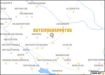
Outeiro das Pratas (Portalegre, Portugal)Outeiro das Pratas is a town in the Portalegre region of Portugal. An overview map of the region around Outeiro das Pratas is displayed below.
regional and 3d topo map of Outeiro das Pratas, Portugal ::
Outeiro das Pratas airports ::
The nearest airport is BJZ - Badajoz Talavera La Real, located 44.8 km south east of Outeiro das Pratas.
Other airports nearby include LIS - Lisbon Lisboa (173.1 km west), SVQ - Sevilla (225.3 km south east), SLM - Salamanca (245.5 km north east), OZP - Sevilla Moron Ab (261.0 km south east), Nearby towns ::
Boavista (0.0km north) //
Monte Novo (1.4km west) //
Martim Filho (1.4km west) //
Esperança (1.9km south) //
Recanto (2.3km north west) //
Marco (3.4km north east) //
La Codosera (4.7km north east) //
Figueira de Cima (4.7km south west) //
Nave Fria (4.3km west) //
Monte Martim Tavares (5.7km south west) //
Vila Flor (5.7km south east) //
Azinhal (7.6km south) //
Barradinhas (8.0km south) //
Baldio (8.6km south east) //
Monte da Figueira de Baixo (8.6km south west) //
Besteiros (9.4km north west) //
[all distances 'as the bird flies' and approximate]  Places with similar names to Outeiro das Pratas, Portugal :: Disclaimer :: Information on this page comes without warranty of any kind |
||
|
Where is Outeiro das Pratas? Elevation and coordinates ::
Latitude (lat): 39°10'0"N Longitude (lon): 7°12'0"W
Elevation (approx.): 367m (map arrows pan, magnifying glasses zoom) |
||
|
Visiting Outeiro das Pratas? Hotel/Accommodation ::
Book a hotel in Outeiro das Pratas Travel Guide ::
Buy a travel guide for Portugal rental cars ::
car rental offers GPS waypoint ::
download a GPX waypoint (PoI) of Outeiro das Pratas for your GPS receiver
|
||