|
search place name
|
||
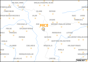
Paçô (Bragança, Portugal)Paçô is a town in the Bragança region of Portugal. An overview map of the region around Paçô is displayed below.
regional and 3d topo map of Paçô, Portugal ::
Paçô airports ::
The nearest airport is BGC - Braganca, located 17.4 km north west of Paçô.
Other airports nearby include VRL - Vila Real (104.4 km south west), SLM - Salamanca (126.2 km south east), VLL - Valladolid (146.9 km east), SCQ - Santiago (197.9 km north west), Nearby towns ::
Rio Frio (2.3km north west) //
Outeiro (4.0km south) //
Veigas (4.6km north east) //
Paradinha (4.5km south east) //
Quintanilha (5.6km north east) //
Vale de Prados (6.2km north west) //
Vilar (6.2km north west) //
Grijó de Parada (5.5km west) //
Milhão (7.5km north) //
San Martín del Pedroso (5.8km east) //
Argozelo (7.5km south) //
Réfega (7.9km north) //
Quinta de Vale de Pena (7.8km south east) //
Coelhoso (8.5km south west) //
[all distances 'as the bird flies' and approximate] 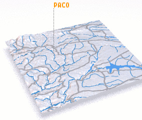 Places with similar names to Paçô, Portugal ::
Disclaimer :: Information on this page comes without warranty of any kind |
||
|
Where is Paçô? Elevation and coordinates ::
Latitude (lat): 41°43'0"N Longitude (lon): 6°37'0"W
Elevation (approx.): 764m (map arrows pan, magnifying glasses zoom) |
||
|
Visiting Paçô? Hotel/Accommodation ::
Book a hotel in Paçô Travel Guide ::
Buy a travel guide for Portugal rental cars ::
car rental offers GPS waypoint ::
download a GPX waypoint (PoI) of Paçô for your GPS receiver
|
||