|
search place name
|
||
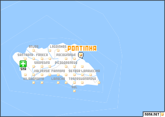
Pontinha (Açores, Portugal)Pontinha is a town in the Açores region of Portugal. An overview map of the region around Pontinha is displayed below.
regional and 3d topo map of Pontinha, Portugal ::
Pontinha airports ::
The nearest airport is SMA - Santa Maria (island) Santa Maria, located 10.8 km west of Pontinha.
Other airports nearby include PDL - Ponta Delgada (101.8 km north west), Nearby towns ::
Azenha de Baixo (1.9km south) //
Lombas (1.9km south) //
Santa Bárbara (1.5km west) //
São Lourenço (1.5km west) //
Cruz de São Mor (2.4km south west) //
Forno de Cima (2.4km south west) //
Azenha de Cima (2.4km south west) //
Santo Espírito (3.7km south) //
Feteirinha (3.7km south) //
Poço Grande (3.0km west) //
Pocilgas (3.0km west) //
Lagos (3.0km west) //
Covão da Mula (3.0km west) //
Pico do Penedo (3.5km south west) //
Setada (4.0km south) //
Loural (4.0km south) //
Almagrinha (4.0km south) //
Lapa de Cima (4.0km south) //
Lapa de Baixo (4.0km south) //
Nossa Senhora de Lourdes (3.5km north west) //
Norte (3.5km north west) //
Lombinha (4.7km south west) //
Terras do Raposo (5.6km south) //
Nossa Senhora da Boa Morte (5.8km south) //
Glória (5.8km south) //
Lagoa (5.8km south) //
Panasco (5.8km south) //
Lagoinhas (4.8km north west) //
Feteiras (4.8km north west) //
[all distances 'as the bird flies' and approximate]  Places with similar names to Pontinha, Portugal ::
Disclaimer :: Information on this page comes without warranty of any kind |
||
|
Where is Pontinha? Elevation and coordinates ::
Latitude (lat): 36°59'0"N Longitude (lon): 25°3'0"W
Elevation (approx.): 96m (map arrows pan, magnifying glasses zoom) |
||
|
Visiting Pontinha? Hotel/Accommodation ::
Book a hotel in Pontinha Travel Guide ::
Buy a travel guide for Portugal rental cars ::
car rental offers GPS waypoint ::
download a GPX waypoint (PoI) of Pontinha for your GPS receiver
|
||