|
search place name
|
||
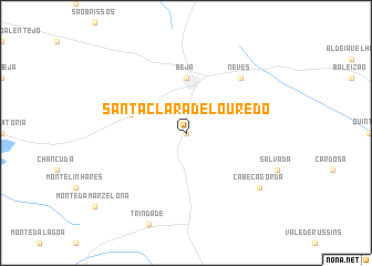
Santa Clara de Louredo (Beja, Portugal)Santa Clara de Louredo is a town in the Beja region of Portugal. An overview map of the region around Santa Clara de Louredo is displayed below.
regional and 3d topo map of Santa Clara de Louredo, Portugal ::
Santa Clara de Louredo airports ::
The nearest airport is FAO - Faro, located 106.1 km south of Santa Clara de Louredo.
Other airports nearby include BJZ - Badajoz Talavera La Real (137.3 km north east), LIS - Lisbon Lisboa (143.1 km north west), SVQ - Sevilla (184.4 km east), XRY - Jerez (209.8 km south east), Nearby towns ::
Boa Vista (0.0km north) //
Beja (5.6km north) //
Penedo Gordo (4.8km north west) //
Neves (7.1km north east) //
Cabeça Gorda (8.1km south east) //
[all distances 'as the bird flies' and approximate] 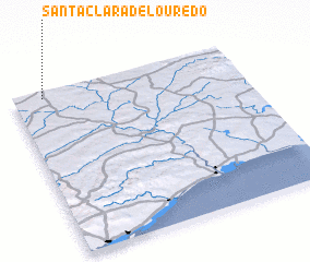 Places with similar names to Santa Clara de Louredo, Portugal :: Disclaimer :: Information on this page comes without warranty of any kind |
||
|
Where is Santa Clara de Louredo? Elevation and coordinates ::
Latitude (lat): 37°58'0"N Longitude (lon): 7°52'0"W
Elevation (approx.): 198m (map arrows pan, magnifying glasses zoom) |
||
|
Visiting Santa Clara de Louredo? Hotel/Accommodation ::
Book a hotel in Santa Clara de Louredo Travel Guide ::
Buy a travel guide for Portugal rental cars ::
car rental offers GPS waypoint ::
download a GPX waypoint (PoI) of Santa Clara de Louredo for your GPS receiver
|
||