|
search place name
|
||
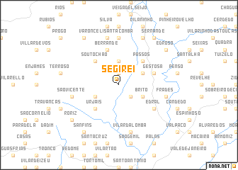
Segirei (Vila Real, Portugal)Segirei is a town in the Vila Real region of Portugal. An overview map of the region around Segirei is displayed below.
regional and 3d topo map of Segirei, Portugal ::
Segirei airports ::
The nearest airport is BGC - Braganca, located 40.9 km east of Segirei.
Other airports nearby include VRL - Vila Real (78.8 km south west), VGO - Vigo (124.9 km west), OPO - Porto (141.4 km south west), SCQ - Santiago (152.0 km north west), Nearby towns ::
Tomonte (1.9km north) //
Sandim (2.3km south east) //
Atrave (3.7km north) //
Vilar Seco da Lomba (3.3km north east) //
Aveleda (3.3km south west) //
Brito (3.3km south east) //
Passos (4.6km north east) //
Soutochao (4.6km north west) //
Urjais (4.6km south west) //
Gestosa (4.5km north east) //
Berrande (5.7km north) //
Edral (5.6km south east) //
Arzoá (7.4km north) //
Varonceli-Santa Comba (7.5km north) //
São Vicente (5.8km west) //
Frades (5.8km east) //
Vilar da Lomba (7.5km south) //
Quiraz (7.9km north) //
Sernande (8.5km north east) //
Moyalde (8.5km north west) //
Edroso (7.8km north east) //
Roriz (7.8km south west) //
Cimo de Vila da Castanheira (8.5km south west) //
Sanfins (8.5km south west) //
[all distances 'as the bird flies' and approximate]  Places with similar names to Segirei, Portugal ::
Disclaimer :: Information on this page comes without warranty of any kind |
||
|
Where is Segirei? Elevation and coordinates ::
Latitude (lat): 41°52'0"N Longitude (lon): 7°12'0"W
Elevation (approx.): 566m (map arrows pan, magnifying glasses zoom) |
||
|
Visiting Segirei? Hotel/Accommodation ::
Book a hotel in Segirei Travel Guide ::
Buy a travel guide for Portugal rental cars ::
car rental offers GPS waypoint ::
download a GPX waypoint (PoI) of Segirei for your GPS receiver
|
||