|
search place name
|
||
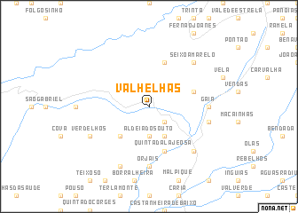
Valhelhas (Guarda, Portugal)Valhelhas is a town in the Guarda region of Portugal. An overview map of the region around Valhelhas is displayed below.
regional and 3d topo map of Valhelhas, Portugal ::
Valhelhas airports ::
The nearest airport is VRL - Vila Real, located 100.8 km north of Valhelhas.
Other airports nearby include OPO - Porto (143.4 km north west), SLM - Salamanca (171.8 km east), BGC - Braganca (172.0 km north), BJZ - Badajoz Talavera La Real (174.7 km south), Nearby towns ::
Vale Formoso (2.3km south east) //
Aldeia do Souto (3.7km south) //
Aldeia do Mato (4.0km south) //
Vale de Amoreira (3.4km north west) //
Sarzedo (4.7km south west) //
Quinta da Lajeosa (5.7km south) //
Gonçalo (4.6km north east) //
Famalicão (5.7km north) //
Orjais (7.4km south) //
Gaia (5.6km east) //
Colmeal (5.9km east) //
Belmonte (7.0km south east) //
Seixo Amarelo (7.0km north east) //
Verdelhos (6.8km south west) //
Cabeço Queimado (7.9km south) //
[all distances 'as the bird flies' and approximate] 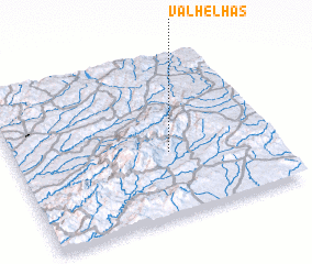 Places with similar names to Valhelhas, Portugal ::
// Valhelhas (PT)
Disclaimer :: Information on this page comes without warranty of any kind |
||
|
Where is Valhelhas? Elevation and coordinates ::
Latitude (lat): 40°24'0"N Longitude (lon): 7°24'0"W
Elevation (approx.): 557m (map arrows pan, magnifying glasses zoom) |
||
|
Visiting Valhelhas? Hotel/Accommodation ::
Book a hotel in Valhelhas Travel Guide ::
Buy a travel guide for Portugal rental cars ::
car rental offers GPS waypoint ::
download a GPX waypoint (PoI) of Valhelhas for your GPS receiver
|
||