|
search place name
|
||
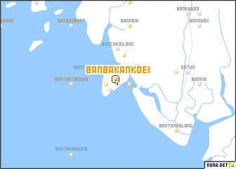
Ban Ba Kan Koei (Satun, Thailand)Ban Ba Kan Koei is a town in the Satun region of Thailand. An overview map of the region around Ban Ba Kan Koei is displayed below.
regional and 3d topo map of Ban Ba Kan Koei, Thailand ::
Ban Ba Kan Koei airports ::
The nearest airport is LGK - Pulau Langkawi Intl, located 39.8 km south west of Ban Ba Kan Koei.
Other airports nearby include HDY - Songkhla Hat Yai Intl (59.8 km north east), AOR - Alor Setar Sultan Abdul Halim (65.9 km south east), TST - Trang (107.7 km north), PAN - Pattani (132.8 km east), Nearby towns ::
Ban Tanyong Po (1.4km south west) //
Changwat Satun (1.8km east) //
Ban Rong Bada (1.8km east) //
Ban Tanjong In (1.8km west) //
Ban Talakanongok (4.1km north west) //
Ban Chebilang (4.7km north) //
Ban Chemilang (5.6km north) //
Ban Tanyong Po (7.4km west) //
[all distances 'as the bird flies' and approximate]  Places with similar names to Ban Ba Kan Koei, Thailand ::
// Ban Ba Kan Ko (TH)
// Ban Ba Kong (TH)
// Ban Bo Kang (TH)
// Ban Buak Ang (TH)
// Ban Bakèng (LA)
// Ban Bakông (LA)
// Bản Bó Củng (VN)
Disclaimer :: Information on this page comes without warranty of any kind |
||
|
Where is Ban Ba Kan Koei? Elevation and coordinates ::
Latitude (lat): 6°36'0"N Longitude (lon): 99°58'0"E
Elevation (approx.): 7m (map arrows pan, magnifying glasses zoom) |
||
|
Visiting Ban Ba Kan Koei? Hotel/Accommodation ::
Book a hotel in Ban Ba Kan Koei Travel Guide ::
Buy a travel guide for Thailand rental cars ::
car rental offers GPS waypoint ::
download a GPX waypoint (PoI) of Ban Ba Kan Koei for your GPS receiver
|
||