|
search place name
|
||
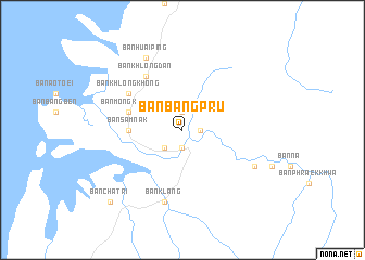
Ban Bang Pru (Ranong, Thailand)Ban Bang Pru is a town in the Ranong region of Thailand. An overview map of the region around Ban Bang Pru is displayed below.
regional and 3d topo map of Ban Bang Pru, Thailand ::
Ban Bang Pru airports ::
The nearest airport is HKT - Phuket Intl, located 167.4 km south of Ban Bang Pru.
Other airports nearby include NST - Nakhon Si Thammarat Cha Ian (194.4 km south east), Nearby towns ::
Ban Bang Lam Phu (1.9km south) //
Ban Bang Pru Nua (1.9km north) //
Ban Dan (1.9km south) //
Kapoe (1.9km south) //
Ban Huai Siat (1.8km east) //
Ban Sami (2.6km south west) //
Ban Samnak (5.5km west) //
Ban Cho (5.5km west) //
Ban Samnak (5.5km west) //
Ban Mong Klang (5.8km west) //
Ban Khlong Dan (6.7km north west) //
Ban Khlong Khong (6.6km north west) //
Ban Bang Hin (7.6km south) //
Ban Klang (7.6km south) //
Ban Huai Ping (8.3km north west) //
Ban Bang Khun Long (8.2km south east) //
Ban Chatri (10.4km south west) //
[all distances 'as the bird flies' and approximate]  Places with similar names to Ban Bang Pru, Thailand ::
// Ban Bang Pra (TH)
Disclaimer :: Information on this page comes without warranty of any kind |
||
|
Where is Ban Bang Pru? Elevation and coordinates ::
Latitude (lat): 9°36'0"N Longitude (lon): 98°36'0"E
Elevation (approx.): 24m (map arrows pan, magnifying glasses zoom) |
||
|
Visiting Ban Bang Pru? Hotel/Accommodation ::
Book a hotel in Ban Bang Pru Travel Guide ::
Buy a travel guide for Thailand rental cars ::
car rental offers GPS waypoint ::
download a GPX waypoint (PoI) of Ban Bang Pru for your GPS receiver
|
||