|
search place name
|
||
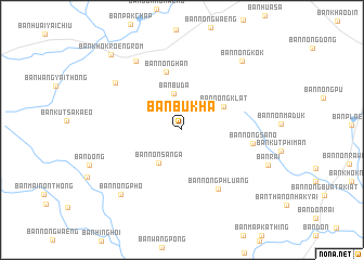
Ban Bu Kha (Nakhon Ratchasima, Thailand)Ban Bu Kha is a town in the Nakhon Ratchasima region of Thailand. An overview map of the region around Ban Bu Kha is displayed below.
regional and 3d topo map of Ban Bu Kha, Thailand ::
Ban Bu Kha airports ::
The nearest airport is NAK - Nakhon Ratchasima Khorat, located 62.9 km south east of Ban Bu Kha.
Other airports nearby include BKK - Bangkok Intl (193.7 km south west), PHS - Phitsanulok (218.2 km north west), Nearby towns ::
Ban Buda (3.8km north) //
Ban Non Sanga (4.1km south west) //
Ban Nong Klat (4.8km north east) //
Ban Nong Han (6.2km north) //
Ban Nong Phluang (7.1km south east) //
Ban Nong Sano (7.1km east) //
Ban Wang Sanuan (8.3km north west) //
Ban Khok Hin Tang (8.4km north west) //
Ban Nong Pho (9.0km south west) //
Ban Nong Kok (9.3km north east) //
Ban Rai (9.3km south east) //
Ban Khok Roeng Rom (10.5km north west) //
[all distances 'as the bird flies' and approximate]  Places with similar names to Ban Bu Kha, Thailand ::
// Ban Ba Khae (TH)
// Ban Bo Kha (TH)
// Ban Bo Kha (TH)
// Ban Bo Kho (TH)
// Ban Bua Khao (TH)
// Ban Buk Hoi (TH)
// Ban Bouakhai (LA)
// Ban Bouak Hia (LA)
// Ban Bouakkhoay (LA)
Disclaimer :: Information on this page comes without warranty of any kind |
||
|
Where is Ban Bu Kha? Elevation and coordinates ::
Latitude (lat): 15°19'53"N Longitude (lon): 101°39'34"E
Elevation (approx.): 237m (map arrows pan, magnifying glasses zoom) |
||
|
Visiting Ban Bu Kha? Hotel/Accommodation ::
Book a hotel in Ban Bu Kha Travel Guide ::
Buy a travel guide for Thailand rental cars ::
car rental offers GPS waypoint ::
download a GPX waypoint (PoI) of Ban Bu Kha for your GPS receiver
|
||