|
search place name
|
||
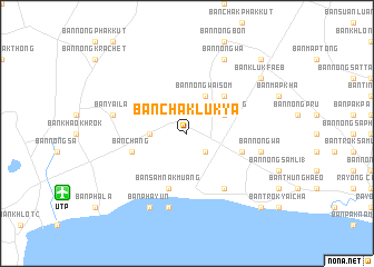
Ban Chak Luk Ya (Rayong, Thailand)Ban Chak Luk Ya is a town in the Rayong region of Thailand. An overview map of the region around Ban Chak Luk Ya is displayed below.
regional and 3d topo map of Ban Chak Luk Ya, Thailand ::
Ban Chak Luk Ya airports ::
The nearest airport is UTP - Rayong U Taphao Intl, located 13.5 km south west of Ban Chak Luk Ya.
Other airports nearby include HHQ - Prachuap Khiri Khan Hua Hin (127.0 km west), BKK - Bangkok Intl (141.7 km north west), Nearby towns ::
Ban Map Chalut (2.6km south east) //
Ban Noen Kraprok (1) (3.6km west) //
Ban Huai Pong (4.1km north east) //
Ban Nong Wai Som (4.1km north east) //
Ban Huai Pong (5.2km north east) //
Ban Map Ta Phut (5.7km east) //
Ban Chang (5.7km west) //
Ban Samnak Muang (5.8km south) //
Ban Ao Pradu (6.6km south east) //
Ban Nong Wa (7.5km east) //
Ban Nam Tok (7.6km south) //
Ban Yai La (7.5km west) //
Ban Phayun (8.2km south west) //
Ban Nong Wa (8.2km north east) //
Ban Kluk Faeb (9.1km north east) //
Ban Takuan (10.4km south east) //
Ban Nong Hin (10.4km north east) //
[all distances 'as the bird flies' and approximate]  Places with similar names to Ban Chak Luk Ya, Thailand :: Disclaimer :: Information on this page comes without warranty of any kind |
||
|
Where is Ban Chak Luk Ya? Elevation and coordinates ::
Latitude (lat): 12°44'0"N Longitude (lon): 101°7'0"E
Elevation (approx.): 40m (map arrows pan, magnifying glasses zoom) |
||
|
Visiting Ban Chak Luk Ya? Hotel/Accommodation ::
Book a hotel in Ban Chak Luk Ya Travel Guide ::
Buy a travel guide for Thailand rental cars ::
car rental offers GPS waypoint ::
download a GPX waypoint (PoI) of Ban Chak Luk Ya for your GPS receiver
|
||