|
search place name
|
||
Ban Chong Maeo (Nakhon Ratchasima, Thailand)Ban Chong Maeo is a town in the Nakhon Ratchasima region of Thailand. An overview map of the region around Ban Chong Maeo is displayed below.
regional and 3d topo map of Ban Chong Maeo, Thailand ::

Ban Chong Maeo airports ::
The nearest airport is NAK - Nakhon Ratchasima Khorat, located 94.9 km west of Ban Chong Maeo.
Other airports nearby include REP - Siem-reap Siem Reap (226.1 km south east), ZVK - Savannakhet (246.1 km north east), SNO - Sakon Nakhon (251.6 km north east), Nearby towns ::
Ban Nong Makhua Noi (3.6km west) //
Ban Nong Yang (4.1km south east) //
Ban Kut Chi (5.8km north) //
Ban Non Hat (5.7km west) //
Ban Chik Yai (7.2km east) //
Ban Nong Kha (7.2km west) //
Ban Kho (7.6km south) //
Ban Khok Yai (7.4km east) //
Ban Hua Dong Lop (7.7km north west) //
Ban Talat Sai (9.2km south west) //
Ban Muang Faek (10.3km south east) //
[all distances 'as the bird flies' and approximate] 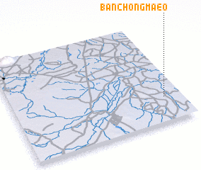 Places with similar names to Ban Chong Maeo, Thailand ::
// Ban Chai Ngam (TH)
// Ban Cha-ngom (TH)
// Ban Chiang Mai (TH)
// Ban Chiang Mai (TH)
// Ban Chiang Mi (TH)
// Ban Chong Maeo (TH)
// Ban Chong Maeo (TH)
// Ban Chien Kum (LA)
Disclaimer :: Information on this page comes without warranty of any kind |
||
|
Where is Ban Chong Maeo? Elevation and coordinates ::
Latitude (lat): 15°15'0"N Longitude (lon): 102°54'0"E
Elevation (approx.): 158m (map arrows pan, magnifying glasses zoom) |
||
|
Visiting Ban Chong Maeo? Hotel/Accommodation ::
Book a hotel in Ban Chong Maeo Travel Guide ::
Buy a travel guide for Thailand rental cars ::
car rental offers GPS waypoint ::
download a GPX waypoint (PoI) of Ban Chong Maeo for your GPS receiver
|
||