|
search place name
|
||
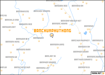
Ban Chumphu Thong (Nong Khai, Thailand)Ban Chumphu Thong is a town in the Nong Khai region of Thailand. An overview map of the region around Ban Chumphu Thong is displayed below.
regional and 3d topo map of Ban Chumphu Thong, Thailand ::
Ban Chumphu Thong airports ::
The nearest airport is VTE - Vientiane Wattay Intl, located 116.9 km west of Ban Chumphu Thong.
Other airports nearby include SNO - Sakon Nakhon (120.9 km south east), UTH - Udon Thani (127.3 km south west), ZVK - Savannakhet (216.0 km south east), LOE - Loei (220.4 km west), Nearby towns ::
Ban Non Muang (4.0km south east) //
Ban Na Charoen (4.4km north west) //
Ban Non Champa (4.7km north east) //
Ban Na Sao (4.8km west) //
Ban Na Sawan (7.1km north west) //
Ban Na Sawan (7.4km north west) //
Ban Lao Yai (7.8km south) //
Ban Kamphaeng Phet (8.1km north east) //
Ban Khok Sawang (9.0km north west) //
Ban Thong Sai (9.4km north east) //
Ban Khok Ngam (9.9km north east) //
Ban Nong To (10.5km north west) //
[all distances 'as the bird flies' and approximate] 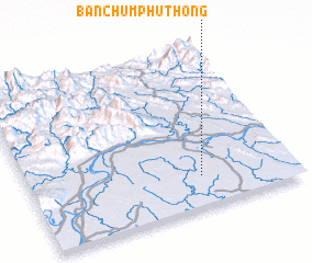 Places with similar names to Ban Chumphu Thong, Thailand :: Disclaimer :: Information on this page comes without warranty of any kind |
||
|
Where is Ban Chumphu Thong? Elevation and coordinates ::
Latitude (lat): 18°11'23"N Longitude (lon): 103°38'50"E
Elevation (approx.): 170m (map arrows pan, magnifying glasses zoom) |
||
|
Visiting Ban Chumphu Thong? Hotel/Accommodation ::
Book a hotel in Ban Chumphu Thong Travel Guide ::
Buy a travel guide for Thailand rental cars ::
car rental offers GPS waypoint ::
download a GPX waypoint (PoI) of Ban Chumphu Thong for your GPS receiver
|
||