|
search place name
|
||
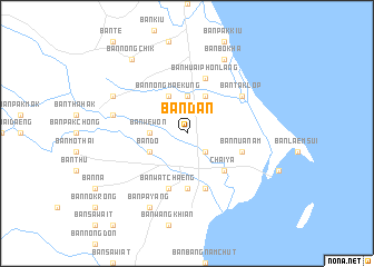
Ban Dan (Surat Thani, Thailand)Ban Dan is a town in the Surat Thani region of Thailand. An overview map of the region around Ban Dan is displayed below.
regional and 3d topo map of Ban Dan, Thailand ::
Ban Dan airports ::
The nearest airport is NST - Nakhon Si Thammarat Cha Ian, located 133.6 km south east of Ban Dan.
Other airports nearby include HKT - Phuket Intl (173.9 km south west), TST - Trang (215.9 km south), Nearby towns ::
Ban Sang (2.6km south east) //
Ban Huai Phon Bon (3.7km north) //
Ban We Won (3.7km west) //
Ban Nong Chik (4.1km north east) //
Ban Nong Mae Kung (4.1km north west) //
Ban Do (4.1km south west) //
Chaiya (5.2km south east) //
Ban Sai Ngam (5.6km south) //
Ban Na Luang (5.6km south) //
Ban Nua Nam (5.8km east) //
Ban Huai Phon Lang (5.9km north) //
Ban Noi (5.9km south) //
Ban Wat Chaeng (5.9km south) //
Ban Taklop (6.6km north east) //
Ban Doem Chao (7.5km west) //
Ban Bo Kha (8.3km north east) //
Ban Khao Phanom Baek (8.2km north west) //
Ban Pa Yang (8.3km south west) //
Ban Nong Chik (9.2km north west) //
[all distances 'as the bird flies' and approximate] 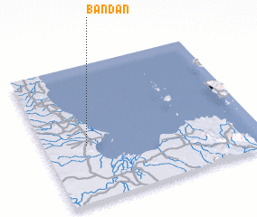 Places with similar names to Ban Dan, Thailand ::
Disclaimer :: Information on this page comes without warranty of any kind |
||
|
Where is Ban Dan? Elevation and coordinates ::
Latitude (lat): 9°25'0"N Longitude (lon): 99°12'0"E
Elevation (approx.): 9m (map arrows pan, magnifying glasses zoom) |
||
|
Visiting Ban Dan? Hotel/Accommodation ::
Book a hotel in Ban Dan Travel Guide ::
Buy a travel guide for Thailand rental cars ::
car rental offers GPS waypoint ::
download a GPX waypoint (PoI) of Ban Dan for your GPS receiver
|
||