|
search place name
|
||
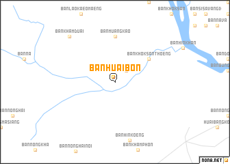
Ban Huai Bon (Ubon Ratchathani, Thailand)Ban Huai Bon is a town in the Ubon Ratchathani region of Thailand. An overview map of the region around Ban Huai Bon is displayed below.
regional and 3d topo map of Ban Huai Bon, Thailand ::
Ban Huai Bon airports ::
The nearest airport is ZVK - Savannakhet, located 57.3 km north of Ban Huai Bon.
Other airports nearby include PKZ - Pakse (137.7 km south east), SNO - Sakon Nakhon (152.2 km north west), Nearby towns ::
Ban Hin Kong (2.6km north east) //
Ban Hin Khan (6.5km north east) //
Ban Khok San Thoeng (6.5km north east) //
Ban Muang Kao (7.4km north) //
Ban Kham Kaeo (7.4km north) //
Ban Kham Duai (10.3km north west) //
[all distances 'as the bird flies' and approximate]  Places with similar names to Ban Huai Bon, Thailand ::
// Ban Huai Bon (TH)
// Ban Huai Bon (TH)
// Ban Huai Bon (TH)
// Ban Huai Bon (TH)
// Ban Huai Bun (TH)
Disclaimer :: Information on this page comes without warranty of any kind |
||
|
Where is Ban Huai Bon? Elevation and coordinates ::
Latitude (lat): 16°4'0"N Longitude (lon): 104°56'0"E
Elevation (approx.): 153m (map arrows pan, magnifying glasses zoom) |
||
|
Visiting Ban Huai Bon? Hotel/Accommodation ::
Book a hotel in Ban Huai Bon Travel Guide ::
Buy a travel guide for Thailand rental cars ::
car rental offers GPS waypoint ::
download a GPX waypoint (PoI) of Ban Huai Bon for your GPS receiver
|
||