|
search place name
|
||
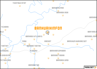
Ban Huai Hin Fon (Tak, Thailand)Ban Huai Hin Fon is a town in the Tak region of Thailand. An overview map of the region around Ban Huai Hin Fon is displayed below.
regional and 3d topo map of Ban Huai Hin Fon, Thailand ::
Ban Huai Hin Fon airports ::
The nearest airport is PHS - Phitsanulok, located 182.6 km east of Ban Huai Hin Fon.
Other airports nearby include LPT - Lampang (195.6 km north east), PRH - Phrae (228.5 km north east), Nearby towns ::
Ban Mae Pa (1.8km east) //
Ban Huai Kalok (1.8km west) //
Mae Sot (3.7km south) //
Ban Mae Kut Luang (5.6km west) //
Ban Hua Fai (6.5km south east) //
Ban Mae Tao Tak (7.7km south west) //
Ban Khang Phiban (8.2km south east) //
Wanchasein (8.0km south west) //
Ban Mae Ka Sa (9.1km north east) //
Myawadi (9.1km south west) //
[all distances 'as the bird flies' and approximate] 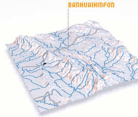 Places with similar names to Ban Huai Hin Fon, Thailand :: Disclaimer :: Information on this page comes without warranty of any kind |
||
|
Where is Ban Huai Hin Fon? Elevation and coordinates ::
Latitude (lat): 16°45'0"N Longitude (lon): 98°34'0"E
Elevation (approx.): 224m (map arrows pan, magnifying glasses zoom) |
||
|
Visiting Ban Huai Hin Fon? Hotel/Accommodation ::
Book a hotel in Ban Huai Hin Fon Travel Guide ::
Buy a travel guide for Thailand rental cars ::
car rental offers GPS waypoint ::
download a GPX waypoint (PoI) of Ban Huai Hin Fon for your GPS receiver
|
||