|
search place name
|
||
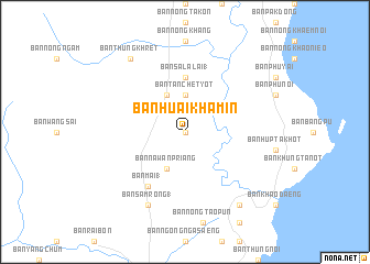
Ban Huai Khamin (Prachuap Khiri Khan, Thailand)Ban Huai Khamin is a town in the Prachuap Khiri Khan region of Thailand. An overview map of the region around Ban Huai Khamin is displayed below.
regional and 3d topo map of Ban Huai Khamin, Thailand ::
Ban Huai Khamin airports ::
The nearest airport is HHQ - Prachuap Khiri Khan Hua Hin, located 48.8 km north of Ban Huai Khamin.
Other airports nearby include UTP - Rayong U Taphao Intl (133.0 km north east), MGZ - Myeik (139.8 km west), BKK - Bangkok Intl (205.1 km north), Nearby towns ::
Ban Sam Roi Yot (0.0km north) //
Ban Tan Chet Yot (3.7km north) //
Ban Na Wan Priang (4.1km south west) //
Ban Rai Kao (4.1km north west) //
Ban Sala Lai (1) (5.6km north) //
Ban Mai (1) (6.6km south west) //
Ban Khao Rang (6.6km south west) //
Ban Don Klang (8.3km south west) //
Ban Samrong (1) (8.3km south west) //
Ban Don Yai Nu (9.2km south east) //
Ban Thung Khret (9.2km north west) //
[all distances 'as the bird flies' and approximate] 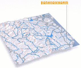 Places with similar names to Ban Huai Khamin, Thailand ::
Disclaimer :: Information on this page comes without warranty of any kind |
||
|
Where is Ban Huai Khamin? Elevation and coordinates ::
Latitude (lat): 12°12'0"N Longitude (lon): 99°53'0"E
(map arrows pan, magnifying glasses zoom) |
||
|
Visiting Ban Huai Khamin? Hotel/Accommodation ::
Book a hotel in Ban Huai Khamin Travel Guide ::
Buy a travel guide for Thailand rental cars ::
car rental offers GPS waypoint ::
download a GPX waypoint (PoI) of Ban Huai Khamin for your GPS receiver
|
||